
Topografische Karte Fletcher
Interaktive Karte
Klicken Sie auf die Karte, um die Höhe anzuzeigen.
Über diese Karte
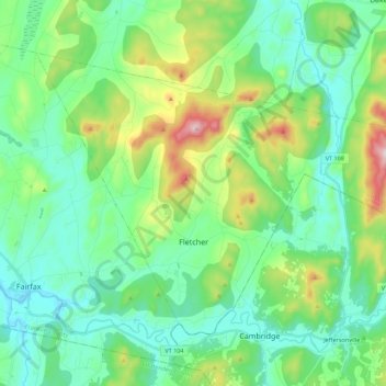
Name: Topografische Karte Fletcher, Höhe, Relief.
Ort: Fletcher, Franklin County, Vermont, 05448, United States (44.64571 -73.00471 44.76055 -72.78366)
Durchschnittliche Höhe: 229 m
Minimale Höhe: 103 m
Maximale Höhe: 611 m
Fletcher is located in southern Franklin County, bordered to the southeast by Lamoille County. According to the United States Census Bureau, the town has a total area of 38.0 square miles (98.4 km2), of which 37.7 square miles (97.7 km2) is land and 0.3 square miles (0.7 km2), or 0.71%, is water. The Lamoille River forms the short southern boundary of the town. Metcalf Pond is located in the north-central part of town. Fletcher Mountain, with a summit elevation of 2,150 feet (660 m), is located at the eastern end of town.
Andere topografische Karten
Klicken Sie auf eine Karte, um ihre Topografie, ihre Höhe und ihr Relief anzuzeigen.
Hectorville
United States > Vermont > Franklin County > Montgomery
Hectorville, Montgomery, Franklin County, Vermont, United States
Durchschnittliche Höhe: 344 m