
Topografische Karte Harran
Interaktive Karte
Klicken Sie auf die Karte, um die Höhe anzuzeigen.
Über diese Karte
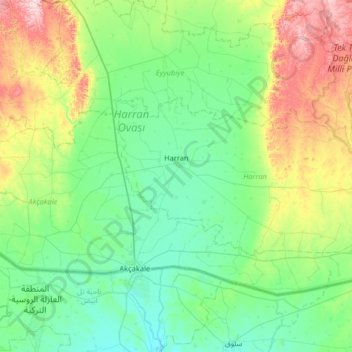
Name: Topografische Karte Harran, Höhe, Relief.
Ort: Harran, Şanlıurfa, Southeastern Anatolia Region, Turkey (36.72714 38.91317 36.96045 39.56120)
Durchschnittliche Höhe: 428 m
Minimale Höhe: 329 m
Maximale Höhe: 754 m
The precise location of the ancient great Ekhulkhul temple is unknown and no certain archaeological evidence of it has yet been found. It is likely that one of the major medieval buildings of Harran displaced the Elkhulkhul and were constructed on top of it, either the Harran Castle or the Grand Mosque. Writings from the Islamic period contradictingly claim that the castle or the mosque were the converted moon temple. The castle being on the site of the ancient temple is further supported by its higher elevation whereas the mosque is further supported by the finds of Babylonian inscriptions and four stelae of Nabonidus among its ruins. These inscriptions and stelae directly mention the Elkhulkhul. Additionally, the remains of an ancient altar with moon iconography have also been recovered from the ruins of the mosque. As a result, the mosque enjoys more scholarly support as the most likely site of the ancient temple.
Andere topografische Karten
Klicken Sie auf eine Karte, um ihre Topografie, ihre Höhe und ihr Relief anzuzeigen.
Karadeniz Mahallesi
Karadeniz Mahallesi, Gaziosmanpaşa, Istanbul, Marmara Region, 34250, Turkey
Durchschnittliche Höhe: 119 m
Sarıkokmaz Mahallesi
Sarıkokmaz Mahallesi, Ereğli, Zonguldak, Black Sea Region, Turkey
Durchschnittliche Höhe: 114 m
Karadeniz Ereğli
Karadeniz Ereğli, Ereğli, Zonguldak, Black Sea Region, 67300, Turkey
Durchschnittliche Höhe: 86 m
Fatih Mahallesi
Fatih Mahallesi, Esenyurt, Istanbul, Marmara Region, Turkey
Durchschnittliche Höhe: 90 m
15 Temmuz Camili Mahallesi
15 Temmuz Camili Mahallesi, Nasuhlar, Adapazarı, Sakarya, Marmara Region, Turkey
Durchschnittliche Höhe: 82 m
Diyarbakir
Diyarbakir, Sur, Diyarbakır, Southeastern Anatolia Region, 21300, Turkey
Durchschnittliche Höhe: 700 m
Sapa
Sapa, Çorum Merkez, Çorum, Black Sea Region, Turkey
Durchschnittliche Höhe: 899 m
Spil Mountain National Park
Turkey > Şehzadeler > Ayvacık
Spil Mountain National Park, Ayvacık, Şehzadeler, Manisa, Aegean Region, Turkey
Durchschnittliche Höhe: 673 m
Şile
Turkey > Marmara Region > Şile > Şile
Şile, Istanbul, Marmara Region, 34980, Turkey
Durchschnittliche Höhe: 28 m
Zeytinburnu
Zeytinburnu, Istanbul, Marmara Region, Turkey
Durchschnittliche Höhe: 37 m
Zeyrek Mahallesi
Turkey > Marmara Region > Zeyrek Mahallesi > Fatih
Zeyrek Mahallesi, Fatih, Istanbul, Marmara Region, Turkey
Durchschnittliche Höhe: 34 m
Güneşli Mahallesi
Turkey > Güneşli Mahallesi > Konak
Güneşli Mahallesi, Konak, Izmir, Aegean Region, Turkey
Durchschnittliche Höhe: 91 m
Çardak
Çardak, Denizli, Aegean Region, 20360, Turkey
Durchschnittliche Höhe: 1.099 m