
Topografische Karte Mussoorie
Klicken Sie auf die Karte, um die Höhe anzuzeigen.
Mussoorie
Mussoorie is at an average altitude of 2,005 metres (6,578 ft). To the northeast are the Himalayan snow ranges, and to the south, the Doon Valley and Shiwalik ranges. The second highest point is the original Lal Tibba in Landour, with a height of over 2,275 m (7,464 ft). Mussoorie is popularly known as The Queen of the Hills.
Über diese Karte
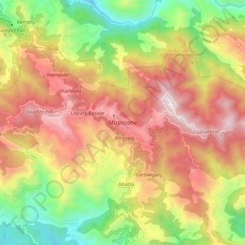
Name: Topografische Karte Mussoorie, Höhe, Relief.
Ort: Mussoorie, Dehradun, Uttarakhand, 248179, India (30.41690 78.03829 30.49690 78.11829)
Durchschnittliche Höhe: 1.594 m
Minimale Höhe: 878 m
Maximale Höhe: 2.285 m