
Topografische Karte Fairy Castle
Interaktive Karte
Klicken Sie auf die Karte, um die Höhe anzuzeigen.
Über diese Karte
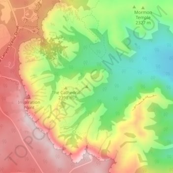
Name: Topografische Karte Fairy Castle, Höhe, Relief.
Ort: Fairy Castle, Garfield County, Utah, 84764, USA (37.61481 -112.15742 37.61491 -112.15732)
Durchschnittliche Höhe: 2.354 m
Minimale Höhe: 2.148 m
Maximale Höhe: 2.551 m
Andere topografische Karten
Klicken Sie auf eine Karte, um ihre Topografie, ihre Höhe und ihr Relief anzuzeigen.
Cedar Breaks National Monument
USA > Utah > North View
Cedar Breaks National Monument, Lower Alpine Pond Trail, North View, Iron County, Utah, USA
Durchschnittliche Höhe: 2.915 m
Jordanelle Reservoir
Jordanelle Reservoir, Jordanelle Perimeter Trail, Hideout, Wasatch County, Utah, USA
Durchschnittliche Höhe: 2.011 m
Grand Staircase-Escalante National Monument
Grand Staircase-Escalante National Monument, Left Hand Collet Road, Kane County, Utah, USA
Durchschnittliche Höhe: 1.857 m
Parleys Summit
Parleys Summit, Summit Park, Salt Lake County, Utah, 84122, USA
Durchschnittliche Höhe: 2.193 m
Provo Peak
Provo Peak, Provo, Utah County, Utah, USA
Durchschnittliche Höhe: 2.903 m
Kolob Reservoir
Kolob Reservoir, Kolob Terrace Road, Washington County, Utah, USA
Durchschnittliche Höhe: 2.499 m
Browns Park
Browns Park, Bountiful, Davis County, Utah, 84010, USA
Durchschnittliche Höhe: 1.556 m
Ashdown Gorge Wilderness Area
Ashdown Gorge Wilderness Area, Summit Canyon Road, Iron County, Utah, 84719, USA
Durchschnittliche Höhe: 2.715 m
Kanab Creek
Kanab Creek, Kanab, Kane County, Utah, 86074, USA
Durchschnittliche Höhe: 1.500 m
Monte Cristo
Monte Cristo, Salt Lake County, Utah, 84138, USA
Durchschnittliche Höhe: 2.909 m
Sundial Peak
Sundial Peak, Salt Lake County, Utah, 84138, USA
Durchschnittliche Höhe: 2.961 m
Great Salt Lake State Park
USA > Utah > Garfield Junction
Great Salt Lake State Park, Garfield Junction, Salt Lake County, Utah, USA
Durchschnittliche Höhe: 1.291 m
Jordan River Off Highway Vehicle Park
Jordan River Off Highway Vehicle Park, Rose Park, Salt Lake County, Utah, USA
Durchschnittliche Höhe: 1.286 m
Canyon Entrance Park
Canyon Entrance Park, Logan, Cache County, Utah, USA
Durchschnittliche Höhe: 1.579 m
Beaver Dam Wash
Beaver Dam Wash, Washington County, Utah, USA
Durchschnittliche Höhe: 1.311 m
Mount Ellen Peak
Mount Ellen Peak, Garfield County, Utah, USA
Durchschnittliche Höhe: 3.098 m
Waterpocket Fold
Waterpocket Fold, UT 24, Fruita, Wayne County, Utah, 84775, USA
Durchschnittliche Höhe: 1.751 m
Haystack Lake
Haystack Lake, Lakes Country Trail, Summit County, Utah, USA
Durchschnittliche Höhe: 3.067 m
Capitol Hill
USA > Utah > Salt Lake City
Capitol Hill, Salt Lake City, Salt Lake County, Utah, 84103, USA
Durchschnittliche Höhe: 1.510 m
Thousand Lake Mountain
Thousand Lake Mountain, Wayne County, Utah, USA
Durchschnittliche Höhe: 3.341 m
Deep Creek Mountains Wilderness Study Area
Deep Creek Mountains Wilderness Study Area, Juab County, Utah, USA
Durchschnittliche Höhe: 1.887 m
Right Fork John Henry Canyon
Right Fork John Henry Canyon, Kane County, Utah, USA
Durchschnittliche Höhe: 1.793 m
Petroglyph Canyon
Petroglyph Canyon, Emery County, Utah, USA
Durchschnittliche Höhe: 1.426 m
Rock Canyon Trailhead
Rock Canyon Trailhead, Provo, Utah County, Utah, USA
Durchschnittliche Höhe: 1.716 m