
Topografische Karte Stella
Interaktive Karte
Klicken Sie auf die Karte, um die Höhe anzuzeigen.
Über diese Karte
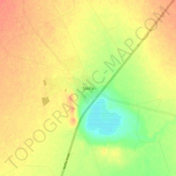
Name: Topografische Karte Stella, Höhe, Relief.
Durchschnittliche Höhe: 1.303 m
Minimale Höhe: 1.276 m
Maximale Höhe: 1.319 m
Andere topografische Karten
Klicken Sie auf eine Karte, um ihre Topografie, ihre Höhe und ihr Relief anzuzeigen.
Vryburg
South Africa > North West > Dr Ruth Segomotsi Mompati District Municipality > Naledi Local Municipality
Vryburg, Naledi Local Municipality, Dr Ruth Segomotsi Mompati District Municipality, North West, 8600, South Africa
Durchschnittliche Höhe: 1.205 m