
Topografische Karte Întorsura Buzăului
Interaktive Karte
Klicken Sie auf die Karte, um die Höhe anzuzeigen.
Über diese Karte
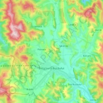
Name: Topografische Karte Întorsura Buzăului, Höhe, Relief.
Ort: Întorsura Buzăului, Covasna, Romania (45.63741 25.95131 45.74807 26.06707)
Durchschnittliche Höhe: 790 m
Minimale Höhe: 652 m
Maximale Höhe: 1.060 m
Întorsura Buzăului is located at 750 m (2,460 ft) altitude, in a depression, surrounded by the Întorsurii [ro], Ciucaș, and Siriu [ro] mountains. Due to its location, the town registers the lowest temperatures in Romania every year.
Andere topografische Karten
Klicken Sie auf eine Karte, um ihre Topografie, ihre Höhe und ihr Relief anzuzeigen.
Băile Bálványos
Băile Bálványos, Turia, Covasna, Romania
Durchschnittliche Höhe: 941 m
Sfântu Gheorghe
Romania > Covasna > Sfântu Gheorghe
Sfântu Gheorghe, Covasna, Romania
Durchschnittliche Höhe: 551 m