
Topografische Karte Frankenburg am Hausruck
Interaktive Karte
Klicken Sie auf die Karte, um die Höhe anzuzeigen.
Über diese Karte
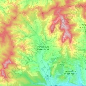
Name: Topografische Karte Frankenburg am Hausruck, Höhe, Relief.
Durchschnittliche Höhe: 594 m
Minimale Höhe: 454 m
Maximale Höhe: 784 m
Frankenburg am Hausruck is situated at an altitude of 519 m in the Hausruckviertel. The extension from north to south is 10.6 km, from west to east 10.3 km. The total area is 48.5 km², 44.5% of the area is forested, 49.3% of the area is used for agriculture.
Andere topografische Karten
Klicken Sie auf eine Karte, um ihre Topografie, ihre Höhe und ihr Relief anzuzeigen.
Attersee am Attersee
Austria > Upper Austria > Bezirk Vöcklabruck
Attersee am Attersee, Bezirk Vöcklabruck, Upper Austria, 4864, Austria
Durchschnittliche Höhe: 512 m
Pöring
Austria > Upper Austria > Bezirk Vöcklabruck > Gampern
Pöring, Gampern, Bezirk Vöcklabruck, Upper Austria, 4851, Austria
Durchschnittliche Höhe: 495 m
Schwanenstadt
Austria > Upper Austria > Bezirk Vöcklabruck > Schwanenstadt
Schwanenstadt, Bezirk Vöcklabruck, Upper Austria, 4690, Austria
Durchschnittliche Höhe: 388 m
Attnang-Puchheim
Austria > Upper Austria > Bezirk Vöcklabruck
Attnang-Puchheim, Bezirk Vöcklabruck, Upper Austria, 4800, Austria
Durchschnittliche Höhe: 428 m
Mondsee
Austria > Upper Austria > Bezirk Vöcklabruck
Mondsee, Bezirk Vöcklabruck, Upper Austria, 5310, Austria
Durchschnittliche Höhe: 666 m