
Topografische Karte Belmullet
Interaktive Karte
Klicken Sie auf die Karte, um die Höhe anzuzeigen.
Über diese Karte
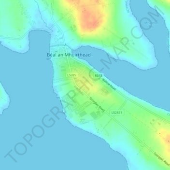
Name: Topografische Karte Belmullet, Höhe, Relief.
Durchschnittliche Höhe: 7 m
Minimale Höhe: -2 m
Maximale Höhe: 38 m
Andere topografische Karten
Klicken Sie auf eine Karte, um ihre Topografie, ihre Höhe und ihr Relief anzuzeigen.
Westport-Belmullet Municipal District
Westport-Belmullet Municipal District, County Mayo, Connacht, Irlande
Durchschnittliche Höhe: 62 m
Clare Island
Clare Island, Westport-Belmullet Municipal District, County Mayo, Connacht, Irlande
Durchschnittliche Höhe: 29 m
Glenagh
Glenagh, Béal Deirg Mór ED, Westport-Belmullet Municipal District, County Mayo, Connacht, Irlande
Durchschnittliche Höhe: 208 m
Aille River
Aille River, Aghagower South ED, Westport-Belmullet Municipal District, County Mayo, Connacht, Irlande
Durchschnittliche Höhe: 83 m
Clare Island ED
Clare Island ED, Westport-Belmullet Municipal District, County Mayo, Connacht, Irlande
Durchschnittliche Höhe: 12 m
Owennadornaun ED
Owennadornaun ED, Westport-Belmullet Municipal District, County Mayo, Connacht, Irlande
Durchschnittliche Höhe: 157 m
Aille River
Aille River, Aghagower South ED, Westport-Belmullet Municipal District, County Mayo, Connacht, Irlande
Durchschnittliche Höhe: 65 m
Béal an Mhuirthead
Irlande > County Mayo > Béal an Mhuirthead
Béal an Mhuirthead, Westport-Belmullet Municipal District, County Mayo, Connacht, Irlande
Durchschnittliche Höhe: 14 m
Fawnglass
Fawnglass, Clare Island ED, Westport-Belmullet Municipal District, County Mayo, Connacht, Irlande
Durchschnittliche Höhe: 32 m
Cloonamanagh
Cloonamanagh, Owennadornaun ED, Westport-Belmullet Municipal District, County Mayo, Connacht, Irlande
Durchschnittliche Höhe: 64 m