Topografische Karte Sto. Tomas
Klicken Sie auf die Karte, um die Höhe anzuzeigen.
Über diese Karte
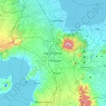
Name: Topografische Karte Sto. Tomas, Höhe, Relief.
Durchschnittliche Höhe: 154 m
Minimale Höhe: -4 m
Maximale Höhe: 1.073 m

Klicken Sie auf die Karte, um die Höhe anzuzeigen.
Name: Topografische Karte Sto. Tomas, Höhe, Relief.
Durchschnittliche Höhe: 154 m
Minimale Höhe: -4 m
Maximale Höhe: 1.073 m