Topografische Karte Westliches Hochland
Interaktive Karte
Klicken Sie auf die Karte, um die Höhe anzuzeigen.
Über diese Karte
![Topografische Karte Westliches Hochland, Höhe, Relief](/pub/maps/relation/lff3/f5g51/thumbnail.jpg)
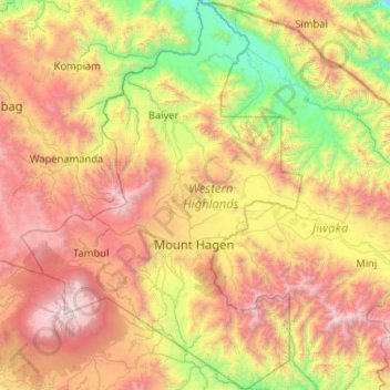
Name: Topografische Karte Westliches Hochland, Höhe, Relief.
Ort: Westliches Hochland, Hochlandregion, Papua-Neuguinea (-6.24445 143.77092 -5.21158 144.52006)
Durchschnittliche Höhe: 1.846 m
Minimale Höhe: 286 m
Maximale Höhe: 4.272 m
Andere topografische Karten
Klicken Sie auf eine Karte, um ihre Topografie, ihre Höhe und ihr Relief anzuzeigen.
![Topografische Karte Südliches Hochland, Höhe, Relief](/pub/maps/relation/r2cz/qhttf/icon.jpg)
Südliches Hochland
Südliches Hochland, Hochlandregion, Papua-Neuguinea
Durchschnittliche Höhe: 1.245 m
![Topografische Karte Östliches Hochland, Höhe, Relief](/pub/maps/relation/d6kl/9rz1h/icon.jpg)
Östliches Hochland
Östliches Hochland, Hochlandregion, Papua-Neuguinea
Durchschnittliche Höhe: 1.498 m
![Topografische Karte Ost-Neubritannien, Höhe, Relief](/pub/maps/relation/xtzs/7w4zzs/icon.jpg)
Ost-Neubritannien
Ost-Neubritannien, Islands Region, Papua-Neuguinea
Durchschnittliche Höhe: 93 m
![Topografische Karte West-Neubritannien, Höhe, Relief](/pub/maps/relation/5mt6/wjs1t6/icon.jpg)
West-Neubritannien
West-Neubritannien, Islands Region, Papua-Neuguinea
Durchschnittliche Höhe: 57 m
![Topografische Karte Nationaler Hauptstadtdistrikt, Höhe, Relief](/pub/maps/relation/5k3l/1w2nx/icon.jpg)
Nationaler Hauptstadtdistrikt
Nationaler Hauptstadtdistrikt, Southern Region, Papua-Neuguinea
Durchschnittliche Höhe: 50 m
![Topografische Karte Tanga Islands, Höhe, Relief](/pub/maps/relation/g5k/3jkvcz/icon.jpg)
Tanga Islands
Tanga Islands, Namatanai District, Neuirland, Islands Region, Papua-Neuguinea
Durchschnittliche Höhe: 6 m
![Topografische Karte Fergusson-Insel, Höhe, Relief](/pub/maps/node/693l/9wz253zs/icon.jpg)
Fergusson-Insel
Fergusson-Insel, Esa’ala District, Milne Bay, Papua Region, Papua-Neuguinea
Durchschnittliche Höhe: 98 m
![Topografische Karte Kadovar, Höhe, Relief](/pub/maps/way/m8mt/4mgm61h/icon.jpg)
Kadovar
Kadovar, Wewak District, East Sepik, Momase Region, Papua-Neuguinea
Durchschnittliche Höhe: 27 m
![Topografische Karte D’Entrecasteaux Islands, Höhe, Relief](/pub/maps/node/d24s/1lb8w57/icon.jpg)
D’Entrecasteaux Islands
D’Entrecasteaux Islands, Esa’ala District, Milne Bay, Papua Region, Papua-Neuguinea
Durchschnittliche Höhe: 102 m
![Topografische Karte Ritter-Insel, Höhe, Relief](/pub/maps/way/l614/bqcjw1h/icon.jpg)
Ritter-Insel
Ritter-Insel, Finschhafen District, Morobe, Momase Region, Papua-Neuguinea
Durchschnittliche Höhe: 1 m
![Topografische Karte Ulawun, Höhe, Relief](/pub/maps/node/slgp/l3h38rnh/icon.jpg)
Ulawun
Papua-Neuguinea > Ost-Neubritannien
Ulawun, Pomio District, Ost-Neubritannien, Islands Region, Papua-Neuguinea
Durchschnittliche Höhe: 1.708 m
![Topografische Karte Mount Balbi, Höhe, Relief](/pub/maps/node/1dm2/x58gn8t6/icon.jpg)
Mount Balbi
Papua-Neuguinea > Bougainville
Mount Balbi, Buka District, Bougainville, Islands Region, Papua-Neuguinea
Durchschnittliche Höhe: 2.393 m
![Topografische Karte Sepik River, Höhe, Relief](/pub/maps/relation/xp57/91lnh/icon.jpg)
Sepik River
Sepik River, Ambunti District, East Sepik, Momase Region, Papua-Neuguinea
Durchschnittliche Höhe: 648 m
![Topografische Karte Goodenough-Insel, Höhe, Relief](/pub/maps/node/s5s8/t6q39nx/icon.jpg)
Goodenough-Insel
Goodenough-Insel, Esa’ala District, Milne Bay, Papua Region, Papua-Neuguinea
Durchschnittliche Höhe: 103 m
![Topografische Karte Neuirland, Höhe, Relief](/pub/maps/relation/jl57/wt2jt6/icon.jpg)
Neuirland
Neuirland, Namatanai District, Neuirland, Islands Region, 675, Papua-Neuguinea
Durchschnittliche Höhe: 83 m
![Topografische Karte Ambitle Island, Höhe, Relief](/pub/maps/relation/8jz4/sbn92cz/icon.jpg)
Ambitle Island
Ambitle Island, Namatanai District, Neuirland, Islands Region, Papua-Neuguinea
Durchschnittliche Höhe: 3 m
![Topografische Karte Umboi, Höhe, Relief](/pub/maps/relation/dv1h/x7rwnh/icon.jpg)
Umboi
Umboi, Finschhafen District, Morobe, Momase Region, Papua-Neuguinea
Durchschnittliche Höhe: 177 m
![Topografische Karte National Capital District, Höhe, Relief](/pub/maps/node/k74s/1lbs457/icon.jpg)
National Capital District
Papua-Neuguinea > Nationaler Hauptstadtdistrikt
National Capital District, Nationaler Hauptstadtdistrikt, Southern Region, 121, Papua-Neuguinea
Durchschnittliche Höhe: 343 m
![Topografische Karte Garove Island, Höhe, Relief](/pub/maps/way/xk9m/917bsnx/icon.jpg)
Garove Island
Papua-Neuguinea > West-Neubritannien
Garove Island, Talasea District, West-Neubritannien, Islands Region, Papua-Neuguinea
Durchschnittliche Höhe: 25 m
![Topografische Karte Rabaul District, Höhe, Relief](/pub/maps/node/k1tf/1lbcb57/icon.jpg)
Rabaul District
Papua-Neuguinea > Ost-Neubritannien
Rabaul District, Ost-Neubritannien, Islands Region, Papua-Neuguinea
Durchschnittliche Höhe: 164 m
![Topografische Karte Neuguinea, Höhe, Relief](/pub/maps/relation/9kzs/sj9qnh/icon.jpg)
Neuguinea
Neuguinea, Kiunga District, West, Papua Region, Papua-Neuguinea
Durchschnittliche Höhe: 101 m