
Spenden
Topografische Karte Port Lorne
Klicken Sie auf die Karte, um die Höhe anzuzeigen.
Spenden
Über diese Karte
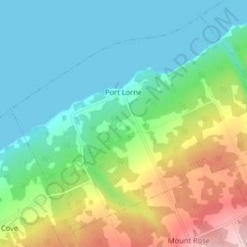
Name: Topografische Karte Port Lorne, Höhe, Relief.
Durchschnittliche Höhe: 71 m
Minimale Höhe: 0 m
Maximale Höhe: 237 m
Spenden
Andere topografische Karten
Klicken Sie auf eine Karte, um ihre Topografie, ihre Höhe und ihr Relief anzuzeigen.
North Mountain
Canada > Nova Scotia > Municipality of the County of Annapolis > Port Royal
Durchschnittliche Höhe: 134 m
Frasertown
Canada > Nova Scotia > Municipality of the County of Annapolis > Princedale
Durchschnittliche Höhe: 138 m
Springfield
Canada > Nova Scotia > Municipality of the County of Annapolis > Springfield
Durchschnittliche Höhe: 178 m
Smith Brook
Canada > Nova Scotia > Municipality of the County of Annapolis > Phinneys Cove
Durchschnittliche Höhe: 39 m
Spenden
Black Rattle
Canada > Nova Scotia > Municipality of the County of Annapolis > Cloud Lake
Durchschnittliche Höhe: 190 m
Milbury Lake
Canada > Nova Scotia > Municipality of the County of Annapolis > Youngs Cove
Durchschnittliche Höhe: 163 m
Bobby Hill
Canada > Nova Scotia > Municipality of the County of Annapolis > Paradise
Durchschnittliche Höhe: 225 m