
Topografische Karte Johannesburg Ward 60
Interaktive Karte
Klicken Sie auf die Karte, um die Höhe anzuzeigen.
Über diese Karte
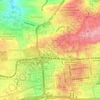
Name: Topografische Karte Johannesburg Ward 60, Höhe, Relief.
Durchschnittliche Höhe: 1.736 m
Minimale Höhe: 1.645 m
Maximale Höhe: 1.802 m
Andere topografische Karten
Klicken Sie auf eine Karte, um ihre Topografie, ihre Höhe und ihr Relief anzuzeigen.
Zoo Lake
RSA > Gauteng > Johannesburg
Zoo Lake, Johannesburg Ward 117, Johannesburg, City of Johannesburg Metropolitan Municipality, Gauteng, 2001, RSA
Durchschnittliche Höhe: 1.647 m
Braamfontein Spruit
RSA > Gauteng > Johannesburg
Braamfontein Spruit, Johannesburg, City of Johannesburg Metropolitan Municipality, Gauteng, 2001, RSA
Durchschnittliche Höhe: 1.672 m
Kliprivier
RSA > Gauteng > Johannesburg
Kliprivier, Johannesburg, City of Johannesburg Metropolitan Municipality, Gauteng, 2001, RSA
Durchschnittliche Höhe: 1.531 m
Johannesburg Ward 87
RSA > Gauteng > Johannesburg
Johannesburg Ward 87, Johannesburg, City of Johannesburg Metropolitan Municipality, Gauteng, 2001, RSA
Durchschnittliche Höhe: 1.661 m
Mary Fitzgerald Square
RSA > Gauteng > Johannesburg
Mary Fitzgerald Square, Johannesburg Ward 60, Johannesburg, City of Johannesburg Metropolitan Municipality, Gauteng, 2001, RSA
Durchschnittliche Höhe: 1.738 m