
Spenden
Topografische Karte Blacksburg
Klicken Sie auf die Karte, um die Höhe anzuzeigen.
Spenden
Blacksburg
Blacksburg exhibits a varied topography characterized by its rolling hills and elevation changes. The town is situated at an average elevation of approximately 2,040 feet (621 meters) above sea level, with elevations ranging from about 1,440 feet (440 meters) to peaks reaching approximately 2,800 feet (860 meters). The landscape is largely influenced by the Appalachian Mountains to the west, contributing to a picturesque setting of steep ridges and valleys. This mountainous terrain is interspersed with waterways, including Stroubles Creek, which meanders through the region, further enhancing the natural beauty. The local geography supports a variety of outdoor recreational opportunities, appealing to both residents and visitors who enjoy hiking, biking, and exploring the scenic vistas.
Spenden
Über diese Karte
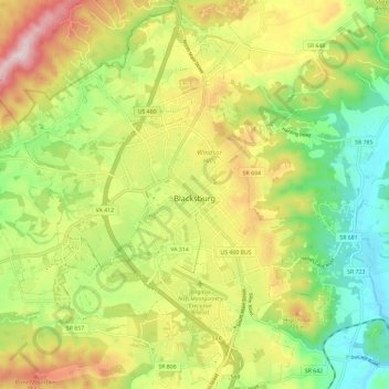
Name: Topografische Karte Blacksburg, Höhe, Relief.
Ort: Blacksburg, Montgomery County, Virginia, United States (37.18389 -80.48068 37.27693 -80.37912)
Durchschnittliche Höhe: 621 m
Minimale Höhe: 440 m
Maximale Höhe: 860 m
Spenden
Andere topografische Karten
Klicken Sie auf eine Karte, um ihre Topografie, ihre Höhe und ihr Relief anzuzeigen.
Ramble Ridge
United States > Virginia > Montgomery County > Blacksburg > Ramble Ridge
Durchschnittliche Höhe: 632 m
Southgate
United States > Virginia > Montgomery County > Blacksburg > Southgate
Durchschnittliche Höhe: 643 m
Spenden