
Topografische Karte Cacouna
Interaktive Karte
Klicken Sie auf die Karte, um die Höhe anzuzeigen.
Über diese Karte
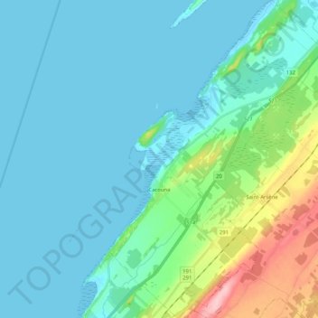
Name: Topografische Karte Cacouna, Höhe, Relief.
Durchschnittliche Höhe: 27 m
Minimale Höhe: -1 m
Maximale Höhe: 156 m
Andere topografische Karten
Klicken Sie auf eine Karte, um ihre Topografie, ihre Höhe und ihr Relief anzuzeigen.
Saint-Hubert-de-Rivière-du-Loup
Canada > Québec > Rivière-du-Loup (MRC)
Saint-Hubert-de-Rivière-du-Loup, Rivière-du-Loup (MRC), Bas-Saint-Laurent, Québec, G0L 3L0, Canada
Durchschnittliche Höhe: 341 m
Saint-Antonin
Canada > Québec > Rivière-du-Loup (MRC) > Saint-Antonin
Saint-Antonin, Rivière-du-Loup (MRC), Bas-Saint-Laurent, Québec, G0L 2J0, Canada
Durchschnittliche Höhe: 224 m
Notre-Dame du-Portage
Canada > Québec > Rivière-du-Loup (MRC)
Notre-Dame du-Portage, Rivière-du-Loup (MRC), Bas-Saint-Laurent, Québec, Canada
Durchschnittliche Höhe: 59 m
Saint-Modeste
Canada > Québec > Rivière-du-Loup (MRC) > Saint-Modeste
Saint-Modeste, Rivière-du-Loup (MRC), Bas-Saint-Laurent, Québec, Canada
Durchschnittliche Höhe: 173 m
Rivière-du-Loup
Canada > Québec > Rivière-du-Loup (MRC)
Rivière-du-Loup, Rivière-du-Loup (MRC), Bas-Saint-Laurent, Québec, Canada
Durchschnittliche Höhe: 64 m
Saint-Paul-de-la-Croix
Canada > Québec > Rivière-du-Loup (MRC)
Saint-Paul-de-la-Croix, Rivière-du-Loup (MRC), Bas-Saint-Laurent, Québec, G0L 1L0, Canada
Durchschnittliche Höhe: 213 m
Fleuve Saint-Laurent, Estuaire moyen
Canada > Québec > Rivière-du-Loup (MRC)
Fleuve Saint-Laurent, Estuaire moyen, Rivière-du-Loup (MRC), Bas-Saint-Laurent, Québec, Canada
Durchschnittliche Höhe: 317 m
L'Isle-Verte
Canada > Québec > Rivière-du-Loup (MRC)
L'Isle-Verte, Rivière-du-Loup (MRC), Bas-Saint-Laurent, Québec, G0L 1K0, Canada
Durchschnittliche Höhe: 53 m
Saint-Arsène
Canada > Québec > Rivière-du-Loup (MRC)
Saint-Arsène, Rivière-du-Loup (MRC), Bas-Saint-Laurent, Québec, G5R 1L7, Canada
Durchschnittliche Höhe: 70 m