
Topografische Karte Ambato
Interaktive Karte
Klicken Sie auf die Karte, um die Höhe anzuzeigen.
Über diese Karte
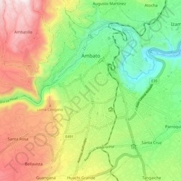
Name: Topografische Karte Ambato, Höhe, Relief.
Ort: Ambato, Tungurahua, Ecuador (-1.30163 -78.65136 -1.21602 -78.56832)
Durchschnittliche Höhe: 2.752 m
Minimale Höhe: 2.345 m
Maximale Höhe: 3.311 m
Ambato (Spanish pronunciation: [amˈbato]; full form, San Juan de Ambato; Quechua: Ampatu Llaqta) is a city located in the central Andean valley of Ecuador. Lying on the banks of the Ambato River, the city also sits beneath several tall mountains. It is the Tungurahua province capital city Tungurahua, at an elevation of 2,577 meters above sea level. It is variously nicknamed "City of Flowers and Fruits", "Land of the Three Juan's", and "Garden of Ecuador." Ambato's inhabitants are called Ambateños or Guaytambos (after a type of native peach that the valley is famous for producing). The current mayor of Ambato is Javier Altamirano.
Andere topografische Karten
Klicken Sie auf eine Karte, um ihre Topografie, ihre Höhe und ihr Relief anzuzeigen.
Ambato
Ecuador > Tungurahua > Ambato > Ambato
Ambato, Tungurahua, 0838, Ecuador
Durchschnittliche Höhe: 3.145 m