
Topografische Karte Lakhimpur
Klicken Sie auf die Karte, um die Höhe anzuzeigen.
Lakhimpur
Lakhimpur is located at 27°57′N 80°46′E / 27.95°N 80.77°E / 27.95; 80.77. It has an average elevation of 147 metres (482 ft).
Über diese Karte
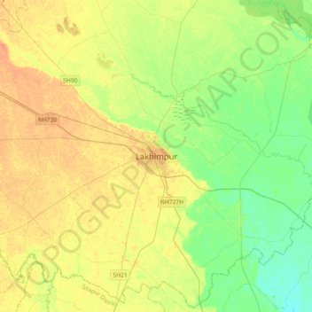
Name: Topografische Karte Lakhimpur, Höhe, Relief.
Durchschnittliche Höhe: 141 m
Minimale Höhe: 126 m
Maximale Höhe: 155 m
Andere topografische Karten
Klicken Sie auf eine Karte, um ihre Topografie, ihre Höhe und ihr Relief anzuzeigen.
Mahakali River
India > Uttar Pradesh > Lakhimpur
The Sharda River is the downstream of Kāli River (or Mahakali River) that originates in the northern Uttarakhand state of India in the Great Himalayas on the eastern slopes of Nanda Devi massif, at an elevation of 3,600 m (11,800 ft) in the Pithoragarh district. It then flows on the Nepal and India border.…
Durchschnittliche Höhe: 135 m