
Topografische Karte Torrance County
Interaktive Karte
Klicken Sie auf die Karte, um die Höhe anzuzeigen.
Über diese Karte
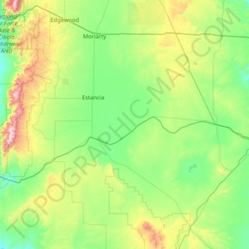
Name: Topografische Karte Torrance County, Höhe, Relief.
Ort: Torrance County, New Mexico, United States (34.25968 -106.47122 35.04214 -105.29014)
Durchschnittliche Höhe: 1.983 m
Minimale Höhe: 1.725 m
Maximale Höhe: 3.035 m
According to the U.S. Census Bureau, the county has a total area of 3,346 square miles (8,670 km2), of which 0.9 square miles (2.3 km2) (0.03%) is covered by water. Most of the county is gently rolling grassland ranging from 6000 to 6200 feet in elevation. The Manzano Mountains rising to 10,098 feet on the western edge of the county provide it with its only significant topographic relief. The Manzano Wilderness area includes the highest part of the mountains. The other notable geographic feature of the county is the series of playas and seasonal lakes centering on Laguna del Perro southeast of Estancia.
Andere topografische Karten
Klicken Sie auf eine Karte, um ihre Topografie, ihre Höhe und ihr Relief anzuzeigen.
Santa Ana Pueblo
United States > New Mexico > Sandoval County
Santa Ana Pueblo, Sandoval County, New Mexico, United States
Durchschnittliche Höhe: 1.576 m
San Francisco
United States > New Mexico > Catron County
San Francisco, Catron County, New Mexico, United States
Durchschnittliche Höhe: 2.440 m
White Sands
United States > New Mexico > Doña Ana County
White Sands, Doña Ana County, New Mexico, 88002, United States
Durchschnittliche Höhe: 1.333 m
Santa Fe
United States > New Mexico > Santa Fe County
Santa Fe, Santa Fe County, New Mexico, United States
Durchschnittliche Höhe: 2.221 m
Catron County
Catron County, New Mexico, United States
Durchschnittliche Höhe: 2.231 m
Roswell
United States > New Mexico > Chaves County
Roswell, Chaves County, New Mexico, United States
Durchschnittliche Höhe: 1.106 m
Grant County
Grant County, New Mexico, United States
Durchschnittliche Höhe: 1.599 m
Riley Black Standpipe, Mount
United States > New Mexico > Doña Ana County
Riley Black Standpipe, Mount, Doña Ana County, New Mexico, United States
Durchschnittliche Höhe: 1.254 m
Standing Rock
United States > New Mexico > McKinley County > Standing Rock
Standing Rock, Eastern Navajo Agency, McKinley County, New Mexico, United States
Durchschnittliche Höhe: 1.931 m
Chama
United States > New Mexico > Rio Arriba County > Chama
Chama, Rio Arriba County, New Mexico, 87520, United States
Durchschnittliche Höhe: 2.430 m
Mount Taylor
United States > New Mexico > Cibola County
Mount Taylor, Cibola County, New Mexico, United States
Durchschnittliche Höhe: 3.168 m
Torreon
United States > New Mexico > Sandoval County
Torreon, Eastern Navajo Agency, Sandoval County, New Mexico, United States
Durchschnittliche Höhe: 1.984 m
Tinian
United States > New Mexico > McKinley County > Tinian
Tinian, McKinley County, New Mexico, United States
Durchschnittliche Höhe: 2.014 m
Rancho Viejo
United States > New Mexico > Rancho Viejo
Rancho Viejo, Santa Fe County, New Mexico, 87507-9720, United States
Durchschnittliche Höhe: 1.979 m
Mora County
Mora County, New Mexico, United States
Durchschnittliche Höhe: 2.150 m
Cibola County
Cibola County, New Mexico, United States
Durchschnittliche Höhe: 2.124 m
Taos County
Taos County, New Mexico, United States
Durchschnittliche Höhe: 2.561 m
Socorro County
Socorro County, New Mexico, United States
Durchschnittliche Höhe: 1.830 m
Santa Fe County
Santa Fe County, New Mexico, United States
Durchschnittliche Höhe: 2.177 m
Bernalillo County
Bernalillo County, New Mexico, United States
Durchschnittliche Höhe: 1.808 m
Lea County
United States > New Mexico > Lea County
Lea County, New Mexico, United States
Durchschnittliche Höhe: 1.100 m
Shiprock
United States > New Mexico > San Juan County
Shiprock, Shiprock Agency, San Juan County, New Mexico, 87420, United States
Durchschnittliche Höhe: 1.524 m
Angel Fire
United States > New Mexico > Colfax County
Angel Fire, Colfax County, New Mexico, 87710, United States
Durchschnittliche Höhe: 2.786 m