
Topografische Karte New Haven County
Interaktive Karte
Klicken Sie auf die Karte, um die Höhe anzuzeigen.
Über diese Karte
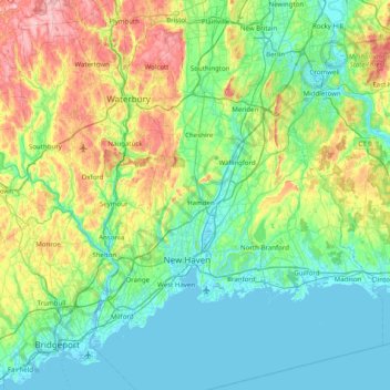
Name: Topografische Karte New Haven County, Höhe, Relief.
Durchschnittliche Höhe: 89 m
Minimale Höhe: -4 m
Maximale Höhe: 385 m
The terrain is mostly flat near the coast, with low hills defining the rest of the area, rising significantly only in the north of the county. The highest elevation is close to the northernmost point in the county, found at two areas of approximately 1,050 feet (320 m) above sea level in the town of Wolcott. The lowest point is sea level.
Andere topografische Karten
Klicken Sie auf eine Karte, um ihre Topografie, ihre Höhe und ihr Relief anzuzeigen.
North Branford
United States > Connecticut > South Central Connecticut Planning Region
North Branford, South Central Connecticut Planning Region, Connecticut, United States
Durchschnittliche Höhe: 68 m
North Rocks
United States > Connecticut > South Central Connecticut Planning Region
North Rocks, South Central Connecticut Planning Region, Connecticut, United States
Durchschnittliche Höhe: 36 m