
Topografische Karte Nestani
Interaktive Karte
Klicken Sie auf die Karte, um die Höhe anzuzeigen.
Über diese Karte
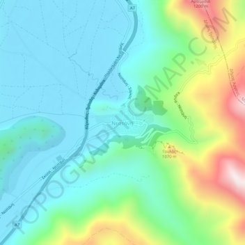
Name: Topografische Karte Nestani, Höhe, Relief.
Durchschnittliche Höhe: 827 m
Minimale Höhe: 623 m
Maximale Höhe: 1.422 m
It is situated at the foot of the mountain Artemisio, at about 700 m elevation. It was the seat of the former municipality Mantineia. The community Nestani also contains the village of Milea. Nestani is 11 km east of Kapsas, 13 km southwest of Lyrkeia (Argolis) and 14 km northeast of Tripoli. The Moreas Motorway (Corinth–Tripoli-Kalamata/Sparta) passes west of the village.
Andere topografische Karten
Klicken Sie auf eine Karte, um ihre Topografie, ihre Höhe und ihr Relief anzuzeigen.
Tower of Nestani
Greece > Peloponnese, Western Greece and the Ionian > Arcadia Regional Unit > Municipal Unit of Mantineia
Tower of Nestani, Corinth - Tripoli - Kalamata, κ. Σάγκα, Community of Nestani, Municipal Unit of Mantineia, Municipality of Tripoli, Arcadia Regional Unit, Peloponnese Region, Peloponnese, Western Greece and the Ionian, 220 05, Greece
Durchschnittliche Höhe: 753 m