
Topografische Karte Pyramid Peak
Interaktive Karte
Klicken Sie auf die Karte, um die Höhe anzuzeigen.
Über diese Karte
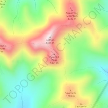
Name: Topografische Karte Pyramid Peak, Höhe, Relief.
Ort: Pyramid Peak, Essex County, New York, USA (44.12347 -73.85599 44.12357 -73.85589)
Durchschnittliche Höhe: 1.084 m
Minimale Höhe: 801 m
Maximale Höhe: 1.441 m
Andere topografische Karten
Klicken Sie auf eine Karte, um ihre Topografie, ihre Höhe und ihr Relief anzuzeigen.
Niagara Falls
USA > New York > Niagara Falls
Niagara Falls, Niagara County, New York, USA
Durchschnittliche Höhe: 180 m
Avalanche Lake
Avalanche Lake, Avalanche Pass Trail, Essex County, New York, USA
Durchschnittliche Höhe: 1.066 m
Flat Top Mountain
Flat Top Mountain, Franklin County, New York, USA
Durchschnittliche Höhe: 568 m
Mount Warren
Mount Warren, Town of Bovina, Delaware County, New York, USA
Durchschnittliche Höhe: 677 m
Buchanan
USA > New York > Buchanan > Town of Cortlandt
Buchanan, Town of Cortlandt, Westchester County, New York, 10511, USA
Durchschnittliche Höhe: 27 m
Falls Creek
Falls Creek, Town of Delhi, Delaware County, New York, 13753, USA
Durchschnittliche Höhe: 515 m
Sawtooth Mountains
Sawtooth Mountains, Franklin County, New York, USA
Durchschnittliche Höhe: 927 m
Crows Nest
Crows Nest, Saint Lawrence County, New York, USA
Durchschnittliche Höhe: 114 m
Lake Champlain
Lake Champlain, Essex County, New York, USA
Durchschnittliche Höhe: 341 m
Farmingville
USA > New York > Farmingville
Farmingville, Suffolk County, New York, 11738, USA
Durchschnittliche Höhe: 47 m
North Western
USA > New York > North Western
North Western, Town of Western, Oneida County, New York, 13486, USA
Durchschnittliche Höhe: 250 m
Livingston Island
Livingston Island, Town of Philipstown, Putnam County, New York, 10922, USA
Durchschnittliche Höhe: 156 m
Boundary Peak
Boundary Peak, Essex County, New York, USA
Durchschnittliche Höhe: 1.175 m
Big Bear Mountain
Big Bear Mountain, Town of Johnsburg, Warren County, New York, USA
Durchschnittliche Höhe: 616 m