
Topografische Karte Flagstaff
Interaktive Karte
Klicken Sie auf die Karte, um die Höhe anzuzeigen.
Über diese Karte
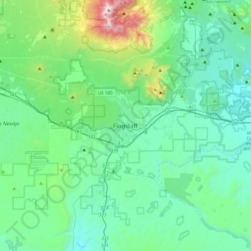
Name: Topografische Karte Flagstaff, Höhe, Relief.
Durchschnittliche Höhe: 2.230 m
Minimale Höhe: 1.895 m
Maximale Höhe: 3.836 m
In 1894, Massachusetts astronomer Percival Lowell hired A. E. Douglass to scout an ideal site for a new observatory. Douglass, impressed by Flagstaff's elevation, named it as an ideal location for the now famous Lowell Observatory, saying: "other things being equal, the higher we can get the better". Two years later, the specially designed 24-inch (610 mm) Clark telescope that Lowell had ordered was installed. In 1930, Pluto was discovered using one of the observatory's telescopes. In 1955 the U.S. Naval Observatory joined the growing astronomical presence, and established the United States Naval Observatory Flagstaff Station, where Pluto's satellite, Charon, was discovered in 1978.