
Topografische Karte Airedale
Interaktive Karte
Klicken Sie auf die Karte, um die Höhe anzuzeigen.
Airedale
This valley is of great topographic significance as it provides low-altitude passes through the mid Pennines to the west coast known as the Aire Gap.
Über diese Karte
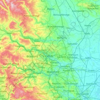
Name: Topografische Karte Airedale, Höhe, Relief.
Durchschnittliche Höhe: 58 m
Minimale Höhe: 0 m
Maximale Höhe: 372 m
Andere topografische Karten
Klicken Sie auf eine Karte, um ihre Topografie, ihre Höhe und ihr Relief anzuzeigen.
Holme upon Spalding Moor
United Kingdom > England > East Riding of Yorkshire
Durchschnittliche Höhe: 6 m
South Cave
United Kingdom > England > East Riding of Yorkshire > South Cave
Durchschnittliche Höhe: 38 m
Full Sutton
United Kingdom > England > East Riding of Yorkshire > Full Sutton
Durchschnittliche Höhe: 18 m
Little Driffield
United Kingdom > England > East Riding of Yorkshire > Driffield
Durchschnittliche Höhe: 30 m
Middleton on the Wolds
United Kingdom > England > East Riding of Yorkshire
Durchschnittliche Höhe: 56 m
High Hunsley
United Kingdom > England > East Riding of Yorkshire > Rowley
Durchschnittliche Höhe: 135 m
Stamford Bridge
United Kingdom > England > East Riding of Yorkshire > Stamford Bridge
Durchschnittliche Höhe: 16 m