
Topografische Karte Narni
Interaktive Karte
Klicken Sie auf die Karte, um die Höhe anzuzeigen.
Über diese Karte
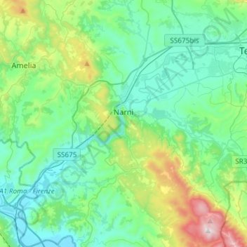
Name: Topografische Karte Narni, Höhe, Relief.
Ort: Narni, Terni, Umbria, 05035, Italy (42.42158 12.41137 42.60082 12.61466)
Durchschnittliche Höhe: 250 m
Minimale Höhe: 42 m
Maximale Höhe: 1.017 m
Narni (Latin: Narnia) is an ancient hilltown and comune of Umbria, in central Italy, with 19,252 inhabitants (2017). At an altitude of 240 metres (790 ft), it overhangs a narrow gorge of the Nera River in the province of Terni. It is very close to the geographic center of Italy. There is a stone on the exact spot with a sign in multiple languages.
Andere topografische Karten
Klicken Sie auf eine Karte, um ihre Topografie, ihre Höhe und ihr Relief anzuzeigen.
Montecchio
Italy > Umbria > Terni > Montecchio
Montecchio, Terni, Umbria, 05020, Italy
Durchschnittliche Höhe: 369 m