
Vielen Dank für die Unterstützung dieser Website ❤️
Spenden
Spenden
Topografische Karte Nedumpana
Klicken Sie auf die Karte, um die Höhe anzuzeigen.
Vielen Dank für die Unterstützung dieser Website ❤️
Spenden
Spenden
Nedumpana
Nedumpana is a countryside in Kollam district featuring a typical kerala village consisting paddy fields, wetlands, river channels and highlands. The area can be categorised into Ida Nadu (Mid land or plains) with an average elevation of 108 meter above mean sea level. Laterite soil and Alluvial Soil constitutes the major soil types. Major rainy season is the South West Monsoon, which bring about 130cm of rain. Out of the total area , 6276 acres of land is culturable.
Vielen Dank für die Unterstützung dieser Website ❤️
Spenden
Spenden
Über diese Karte
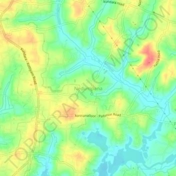
Name: Topografische Karte Nedumpana, Höhe, Relief.
Ort: Nedumpana, Kollam, Kerala, 691580, India (8.88875 76.67450 8.92875 76.71450)
Durchschnittliche Höhe: 26 m
Minimale Höhe: 1 m
Maximale Höhe: 60 m
Vielen Dank für die Unterstützung dieser Website ❤️
Spenden
Spenden