
Spenden
Topografische Karte Estancia
Klicken Sie auf die Karte, um die Höhe anzuzeigen.
Spenden
Über diese Karte
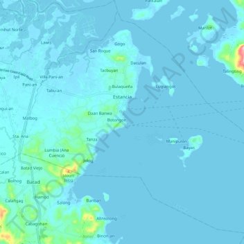
Name: Topografische Karte Estancia, Höhe, Relief.
Ort: Estancia, Iloilo, Western Visayas, 5017, Philippines (11.39493 123.10425 11.49529 123.21661)
Durchschnittliche Höhe: 11 m
Minimale Höhe: -2 m
Maximale Höhe: 210 m
Spenden
Andere topografische Karten
Klicken Sie auf eine Karte, um ihre Topografie, ihre Höhe und ihr Relief anzuzeigen.
Janiuay
Santo Tomas approximate population is 500–800. Santo Tomas (Pakol to locals) is bounded by Madong in the east, Mangil in the north-east and Danao in the south west. It is accessible by three class C feeder roads in the east, south-west and south-east. Agriculture centers around rice, corn, coffee, beans,…
Durchschnittliche Höhe: 82 m
Spenden
Spenden
Spenden
Spenden
Spenden
Spenden
Spenden
Spenden
Spenden
Spenden
Tubungan
Tubungan is 41 kilometres (25 mi) from Iloilo City. With a land area of 8,518 hectares (21,050 acres) found a hundred feet above sea level, the municipality's topography is dominated mostly by gentle rolling hills and idyllic mountains. The slope gradient ranges to as high as 25 per cent in most areas giving…
Durchschnittliche Höhe: 153 m
Spenden
Spenden
Bingawan
Bingawan is relatively dry from November to April and wet during the rest of the year. The maximum rain periods are not very heavy with a short dry season lasting from one to three months. The climate is influenced by the southeast monsoons, one of the principal air streams affecting the country. Local…
Durchschnittliche Höhe: 64 m
Spenden
Spenden
Santa Barbara
The topography of Santa Barbara varies from slightly rolling hills to almost flat or gradually inclined plains, sliced by Tigum River at its centremost, which flows from the north-west to the southeast and the Aganan River in the southern section.
Durchschnittliche Höhe: 34 m
Spenden
Spenden
Spenden
Spenden
Spenden
Spenden
Spenden
Spenden
Spenden
Spenden
Spenden