Geolokalisieren

Topografische Karte Via

Interaktive Karte

Klicken Sie auf die Karte, um die Höhe anzuzeigen.

Über diese Karte

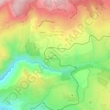
Name: Topografische Karte Via, Höhe, Relief.

Ort: Via, Font-Romeu-Odeillo-Via, Prades, Pyrénées-Orientales, Occitanie, France métropolitaine, 66120, France (42.46858 2.02059 42.50858 2.06059)

Durchschnittliche Höhe: 1.551 m

Minimale Höhe: 1.280 m

Maximale Höhe: 1.851 m

Le village de Via se situe à une altitude de 1 510 mètres.

Wikipedia (CC-BY-SA 3.0)

Andere topografische Karten

Klicken Sie auf eine Karte, um ihre Topografie, ihre Höhe und ihr Relief anzuzeigen.

Font-Romeu

France > Occitanie > Pyrénées-Orientales > Font-Romeu-Odeillo-Via

Font-Romeu, Font-Romeu-Odeillo-Via, Prades, Pyrénées-Orientales, Occitanie, France métropolitaine, 66120, France

Durchschnittliche Höhe: 1.710 m

Odeillo

France > Occitanie > Pyrénées-Orientales > Font-Romeu-Odeillo-Via

Odeillo, Font-Romeu-Odeillo-Via, Prades, Pyrénées-Orientales, Occitanie, France métropolitaine, 66120, France

Durchschnittliche Höhe: 1.631 m

L'Ermitage

France > Occitanie > Pyrénées-Orientales > Font-Romeu-Odeillo-Via

L'Ermitage, Font-Romeu-Odeillo-Via, Prades, Pyrénées-Orientales, Occitanie, France métropolitaine, 66120, France

Durchschnittliche Höhe: 1.785 m