
Topografische Karte Fort Scott
Interaktive Karte
Klicken Sie auf die Karte, um die Höhe anzuzeigen.
Über diese Karte
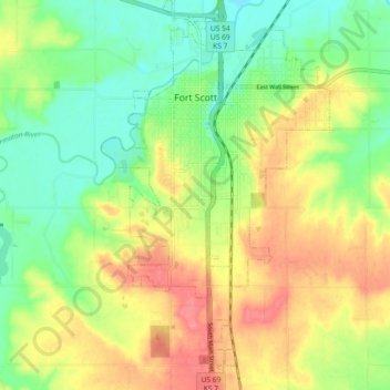
Name: Topografische Karte Fort Scott, Höhe, Relief.
Ort: Fort Scott, Bourbon County, Kansas, 66701, United States (37.78583 -94.73034 37.85780 -94.67602)
Durchschnittliche Höhe: 266 m
Minimale Höhe: 235 m
Maximale Höhe: 303 m
Fort Scott is located at 37°50′7″N 94°42′7″W / 37.83528°N 94.70194°W / 37.83528; -94.70194 (37.835180, −94.702015) at an elevation of 846 feet (258 m). It lies on the Osage Plains on the south side of the Marmaton River. Located at the intersection of U.S. Routes 54 and 69 in southeast Kansas, Fort Scott is approximately 54 miles (87 km) north of Joplin, Missouri, 92 miles (148 km) south of Kansas City, and 143 miles (230 km) east of Wichita.
Andere topografische Karten
Klicken Sie auf eine Karte, um ihre Topografie, ihre Höhe und ihr Relief anzuzeigen.
Garland
United States > Kansas > Bourbon County
Garland, Bourbon County, Kansas, 66741, United States
Durchschnittliche Höhe: 259 m
Redfield
United States > Kansas > Bourbon County
Redfield, Bourbon County, Kansas, United States
Durchschnittliche Höhe: 263 m
Hammond
United States > Kansas > Bourbon County
Hammond, Bourbon County, Kansas, United States
Durchschnittliche Höhe: 266 m
Marmaton
United States > Kansas > Bourbon County
Marmaton, Bourbon County, Kansas, United States
Durchschnittliche Höhe: 266 m
Mapleton
United States > Kansas > Bourbon County
Mapleton, Bourbon County, Kansas, United States
Durchschnittliche Höhe: 267 m
Berlin
United States > Kansas > Bourbon County
Berlin, Bourbon County, Kansas, United States
Durchschnittliche Höhe: 293 m
Devon
United States > Kansas > Bourbon County
Devon, Bourbon County, Kansas, United States
Durchschnittliche Höhe: 268 m
Harding
United States > Kansas > Bourbon County
Harding, Bourbon County, Kansas, 66764, United States
Durchschnittliche Höhe: 267 m
Pawnee Station
United States > Kansas > Bourbon County
Pawnee Station, Bourbon County, Kansas, United States
Durchschnittliche Höhe: 296 m
Xenia
United States > Kansas > Bourbon County
Xenia, Bourbon County, Kansas, United States
Durchschnittliche Höhe: 295 m
Bronson
United States > Kansas > Bourbon County
Bronson, Bourbon County, Kansas, United States
Durchschnittliche Höhe: 323 m
Fulton
United States > Kansas > Bourbon County
Fulton, Bourbon County, Kansas, 66738, United States
Durchschnittliche Höhe: 252 m
Barnesville
United States > Kansas > Bourbon County
Barnesville, Bourbon County, Kansas, United States
Durchschnittliche Höhe: 252 m
Godfrey
United States > Kansas > Bourbon County
Godfrey, Bourbon County, Kansas, United States
Durchschnittliche Höhe: 287 m
Hiattville
United States > Kansas > Bourbon County
Hiattville, Bourbon County, Kansas, United States
Durchschnittliche Höhe: 293 m
Porterville
United States > Kansas > Bourbon County
Porterville, Bourbon County, Kansas, United States
Durchschnittliche Höhe: 317 m
Uniontown
United States > Kansas > Bourbon County
Uniontown, Bourbon County, Kansas, United States
Durchschnittliche Höhe: 275 m