Geolokalisieren
👉 Easily get elevation data in JSON, GeoTIFF and KML formats using Elevation API
Vielen Dank für die Unterstützung dieser Website ❤️
Spenden

Topografische Karte Málaga

Klicken Sie auf die Karte, um die Höhe anzuzeigen.

👉 Easily get elevation data in JSON, GeoTIFF and KML formats using Elevation API
Vielen Dank für die Unterstützung dieser Website ❤️
Spenden

Málaga

Like many of the military fortifications that were constructed in Islamic Spain, the Alcazaba of Málaga featured a quadrangular plan. It was protected by an outer and inner wall, both supported by rectangular towers, between which a covered walkway led up the slope to the Gibralfaro (this was the only exchange between the two sites). Due to its rough and awkward hillside topography, corridors throughout the site provided a means of communications for administrative and defensive operations, also affording privacy to the palatial residential quarters.

👉 Easily get elevation data in JSON, GeoTIFF and KML formats using Elevation API
Vielen Dank für die Unterstützung dieser Website ❤️
Spenden

Über diese Karte

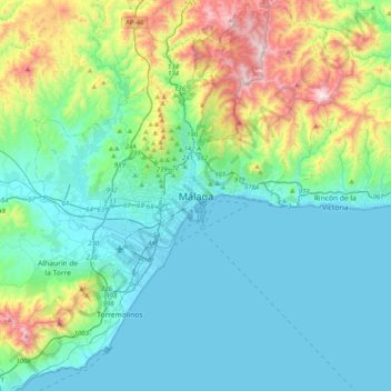
Name: Topografische Karte Málaga, Höhe, Relief.

Ort: Málaga, Málaga-Costa del Sol, Malaga, Andalusia, 29008, Spain (36.56130 -4.58164 36.88130 -4.26164)

Durchschnittliche Höhe: 215 m

Minimale Höhe: -1 m

Maximale Höhe: 1.019 m

👉 Easily get elevation data in JSON, GeoTIFF and KML formats using Elevation API
Vielen Dank für die Unterstützung dieser Website ❤️
Spenden

Andere topografische Karten

Klicken Sie auf eine Karte, um ihre Topografie, ihre Höhe und ihr Relief anzuzeigen.

Churriana

Spain > Andalusia > Málaga-Costa del Sol > Málaga

Durchschnittliche Höhe: 51 m

Teatinos-Universidad

Spain > Andalusia > Málaga-Costa del Sol > Málaga

Durchschnittliche Höhe: 59 m

Puerto de la Torre

Spain > Andalusia > Málaga-Costa del Sol > Málaga

Durchschnittliche Höhe: 196 m

Bailén-Miraflores

Spain > Andalusia > Málaga-Costa del Sol > Málaga

Durchschnittliche Höhe: 79 m

Vielen Dank für die Unterstützung dieser Website ❤️
Spenden

Baños del Carmen

Spain > Andalusia > Málaga-Costa del Sol > Málaga

Durchschnittliche Höhe: 31 m

Este

Spain > Andalusia > Málaga-Costa del Sol > Málaga

Durchschnittliche Höhe: 423 m

El Candado

Spain > Andalusia > Málaga-Costa del Sol > Málaga

Durchschnittliche Höhe: 36 m

Este

Spain > Andalusia > Málaga-Costa del Sol > Málaga

Durchschnittliche Höhe: 423 m

Vielen Dank für die Unterstützung dieser Website ❤️
Spenden

Este

Spain > Andalusia > Málaga-Costa del Sol > Málaga

Durchschnittliche Höhe: 423 m

Carretera de Cádiz

Spain > Andalusia > Málaga-Costa del Sol > Málaga

Durchschnittliche Höhe: 8 m

Centro

Spain > Andalusia > Málaga-Costa del Sol > Málaga

Durchschnittliche Höhe: 26 m

Pinares de San Antón

Spain > Andalusia > Málaga-Costa del Sol > Málaga

Durchschnittliche Höhe: 161 m

Vielen Dank für die Unterstützung dieser Website ❤️
Spenden

Campanillas

Spain > Andalusia > Málaga-Costa del Sol > Málaga

Durchschnittliche Höhe: 108 m

Centro

Spain > Andalusia > Málaga-Costa del Sol > Málaga

Durchschnittliche Höhe: 26 m

Puerto de la Torre

Spain > Andalusia > Málaga-Costa del Sol > Málaga

Durchschnittliche Höhe: 196 m

Churriana

Spain > Andalusia > Málaga-Costa del Sol > Málaga

Durchschnittliche Höhe: 51 m

Vielen Dank für die Unterstützung dieser Website ❤️
Spenden