Geolokalisieren
👉 Easily get elevation data in JSON, GeoTIFF and KML formats using Elevation API
Vielen Dank für die Unterstützung dieser Website ❤️
Spenden

Topografische Karte Black Hill

Klicken Sie auf die Karte, um die Höhe anzuzeigen.

👉 Easily get elevation data in JSON, GeoTIFF and KML formats using Elevation API
Vielen Dank für die Unterstützung dieser Website ❤️
Spenden

Über diese Karte

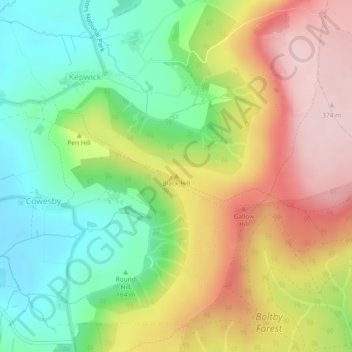
Name: Topografische Karte Black Hill, Höhe, Relief.

Ort: Black Hill, Hambleton, North Yorkshire, Yorkshire and the Humber, England, YO7 2JS, United Kingdom (54.30427 -1.26866 54.30437 -1.26856)

Durchschnittliche Höhe: 232 m

Minimale Höhe: 115 m

Maximale Höhe: 375 m

👉 Easily get elevation data in JSON, GeoTIFF and KML formats using Elevation API
Vielen Dank für die Unterstützung dieser Website ❤️
Spenden

Andere topografische Karten

Klicken Sie auf eine Karte, um ihre Topografie, ihre Höhe und ihr Relief anzuzeigen.

Well

United Kingdom > England > North Yorkshire > Hambleton

Durchschnittliche Höhe: 72 m

Faceby

United Kingdom > England > North Yorkshire > Hambleton

Durchschnittliche Höhe: 138 m

Ellerbeck

United Kingdom > England > North Yorkshire > Hambleton

Durchschnittliche Höhe: 97 m

Skutterskelfe

United Kingdom > England > North Yorkshire > Hambleton > Rudby

Durchschnittliche Höhe: 70 m

Vielen Dank für die Unterstützung dieser Website ❤️
Spenden

Thimbleby

United Kingdom > England > North Yorkshire > Hambleton > Thimbleby

Durchschnittliche Höhe: 166 m

Rudby

United Kingdom > England > North Yorkshire > Hambleton

Durchschnittliche Höhe: 69 m

Whorlton

United Kingdom > England > North Yorkshire > Hambleton

Durchschnittliche Höhe: 180 m

Vielen Dank für die Unterstützung dieser Website ❤️
Spenden

Flawith

United Kingdom > England > North Yorkshire > Hambleton

Durchschnittliche Höhe: 21 m