
Topografische Karte Mountain View
Interaktive Karte
Klicken Sie auf die Karte, um die Höhe anzuzeigen.
Über diese Karte
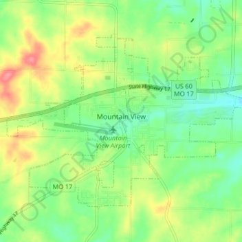
Name: Topografische Karte Mountain View, Höhe, Relief.
Ort: Mountain View, Howell County, Missouri, United States (36.97552 -91.73461 37.01306 -91.66962)
Durchschnittliche Höhe: 362 m
Minimale Höhe: 331 m
Maximale Höhe: 409 m
Andere topografische Karten
Klicken Sie auf eine Karte, um ihre Topografie, ihre Höhe und ihr Relief anzuzeigen.
Pottersville
United States > Missouri > Howell County
Pottersville, Howell County, Missouri, 65790, United States
Durchschnittliche Höhe: 303 m
South Fork
United States > Missouri > Howell County
South Fork, Howell County, Missouri, United States
Durchschnittliche Höhe: 333 m
Lanton
United States > Missouri > Howell County
Lanton, Howell County, Missouri, United States
Durchschnittliche Höhe: 262 m
Brandsville
United States > Missouri > Howell County
Brandsville, Howell County, Missouri, 65688, United States
Durchschnittliche Höhe: 294 m
Pomona
United States > Missouri > Howell County
Pomona, Howell County, Missouri, 65789, United States
Durchschnittliche Höhe: 372 m
Moody
United States > Missouri > Howell County
Moody, Howell County, Missouri, 65777, United States
Durchschnittliche Höhe: 293 m
Peace Valley
United States > Missouri > Howell County
Peace Valley, Howell County, Missouri, United States
Durchschnittliche Höhe: 322 m
Sterling
United States > Missouri > Howell County
Sterling, Howell County, Missouri, United States
Durchschnittliche Höhe: 435 m
Caulfield
United States > Missouri > Howell County
Caulfield, Howell County, Missouri, United States
Durchschnittliche Höhe: 309 m
West Plains
United States > Missouri > Howell County
West Plains, Howell County, Missouri, 65775, United States
Durchschnittliche Höhe: 321 m
Summers Addition
United States > Missouri > Howell County > West Plains
Summers Addition, West Plains, Howell County, Missouri, 65775, United States
Durchschnittliche Höhe: 306 m
Kelly Park
United States > Missouri > Howell County > West Plains
Kelly Park, West Plains, Howell County, Missouri, United States
Durchschnittliche Höhe: 292 m