
Topografische Karte Moosic
Interaktive Karte
Klicken Sie auf die Karte, um die Höhe anzuzeigen.
Moosic
Moosic is located in the Wyoming Valley of northeastern Pennsylvania. In terms of physiography, Moosic is part of the Ridge and Valley province of the Appalachian Mountains. Moosic is located at an elevation of 817 feet (249 m) above sea level. The major body of water flowing through the borough is the Lackawanna River, part of the Upper Susquehanna-Lackawanna Watershed. Moosic has a total area of 6.6 square miles (17 km2), of which 6.5 square miles (17 km2) is land and 0.1 square miles (0.26 km2) (1.52%) is water. Moosic has a humid continental climate (Köppen Dfa) with four distinct seasons. Summers are humid and warm, with an occasional heatwave. Winters are cold and snowy.
Über diese Karte
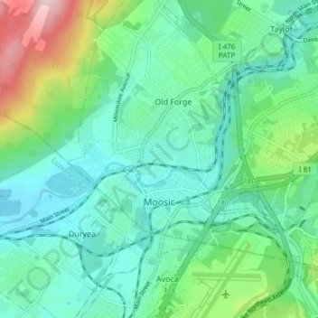
Name: Topografische Karte Moosic, Höhe, Relief.
Durchschnittliche Höhe: 246 m
Minimale Höhe: 166 m
Maximale Höhe: 505 m
Andere topografische Karten
Klicken Sie auf eine Karte, um ihre Topografie, ihre Höhe und ihr Relief anzuzeigen.
Mount Cobb
United States > Pennsylvania > Lackawanna County > Jefferson Township
Durchschnittliche Höhe: 529 m
Moosic Lakes
United States > Pennsylvania > Lackawanna County > Jefferson Township
Durchschnittliche Höhe: 617 m
Crestwood
United States > Pennsylvania > Lackawanna County > Roaring Brook Township
Durchschnittliche Höhe: 512 m
Madisonville
United States > Pennsylvania > Lackawanna County > Madison Township
Durchschnittliche Höhe: 512 m
Moosic Lakes
United States > Pennsylvania > Lackawanna County > Jefferson Township
Durchschnittliche Höhe: 615 m
Chinchilla
United States > Pennsylvania > Lackawanna County > South Abington Township
Durchschnittliche Höhe: 430 m
Finn Hill
United States > Pennsylvania > Lackawanna County > Benton Township
Durchschnittliche Höhe: 414 m
Church Hill
United States > Pennsylvania > Lackawanna County > Benton Township
Durchschnittliche Höhe: 362 m
Justus
United States > Pennsylvania > Lackawanna County > Scott Township
Durchschnittliche Höhe: 481 m
Lake Hide Away
United States > Pennsylvania > Lackawanna County > Moscow > Harmony Hills
Durchschnittliche Höhe: 518 m
Crystal Lake
United States > Pennsylvania > Lackawanna County > Clifford Township
Durchschnittliche Höhe: 527 m
Mount Cobb
United States > Pennsylvania > Lackawanna County > Jefferson Township
Durchschnittliche Höhe: 525 m
Keyser Valley
United States > Pennsylvania > Lackawanna County > Scranton
Durchschnittliche Höhe: 328 m