
Spenden
Topografische Karte Bragg Creek
Klicken Sie auf die Karte, um die Höhe anzuzeigen.
Spenden
Über diese Karte
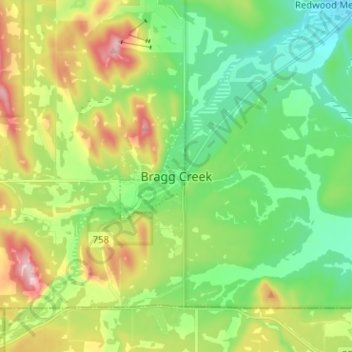
Name: Topografische Karte Bragg Creek, Höhe, Relief.
Ort: Bragg Creek, Rocky View County, Alberta, T0L 0K0, Canada (50.91147 -114.60289 50.99147 -114.52289)
Durchschnittliche Höhe: 1.332 m
Minimale Höhe: 1.247 m
Maximale Höhe: 1.494 m
Spenden
Andere topografische Karten
Klicken Sie auf eine Karte, um ihre Topografie, ihre Höhe und ihr Relief anzuzeigen.
Langdon
Canada > Alberta > Rocky View County
Langdon is located 12 km (7.5 mi) east of the City of Calgary at the intersection of Highway 560 (Glenmore Trail) and Highway 797, approximately 6 km (3.7 mi) south of the Trans Canada Highway and 7 km (4.3 mi) north of Highway 22X. It has an elevation of 1,005 m (3,297 ft).
Durchschnittliche Höhe: 1.007 m
Tsuut'ina Nation
Canada > Alberta > Rocky View County > Redwood Meadows
Durchschnittliche Höhe: 1.225 m
Spenden