Geolokalisieren

Topografische Karte Santa Maria

Interaktive Karte

Klicken Sie auf die Karte, um die Höhe anzuzeigen.

Über diese Karte

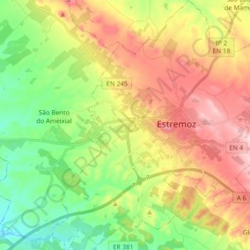
Name: Topografische Karte Santa Maria, Höhe, Relief.

Ort: Santa Maria, Estremoz, Évora, Portugal (38.79105 -7.65357 38.89425 -7.52748)

Durchschnittliche Höhe: 336 m

Minimale Höhe: 223 m

Maximale Höhe: 480 m

Andere topografische Karten

Klicken Sie auf eine Karte, um ihre Topografie, ihre Höhe und ihr Relief anzuzeigen.

Arcos

Portugal > Évora > Estremoz

Arcos, Estremoz, Évora, Portugal

Durchschnittliche Höhe: 436 m

Caldeireiros

Portugal > Évora > Estremoz

Caldeireiros, Estremoz, Évora, 7100-032, Portugal

Durchschnittliche Höhe: 458 m

Évoramonte

Portugal > Évora > Estremoz

Évoramonte, Estremoz, Évora, 7100-308, Portugal

Durchschnittliche Höhe: 328 m

Estremoz

Portugal > Évora > Estremoz > Estremoz

Estremoz, Évora, Alentejo, 7100-513, Portugal

Durchschnittliche Höhe: 378 m

Ossa

Portugal > Évora > Estremoz

Ossa, Estremoz, Évora, 7170-120, Portugal

Durchschnittliche Höhe: 463 m

Ameixial (Santa Vitória e São Bento)

Portugal > Évora > Estremoz

Ameixial (Santa Vitória e São Bento), Estremoz, Évora, Portugal

Durchschnittliche Höhe: 290 m