
Topografische Karte Wayne County
Interaktive Karte
Klicken Sie auf die Karte, um die Höhe anzuzeigen.
Über diese Karte
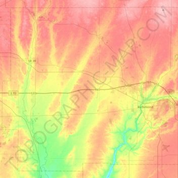
Name: Topografische Karte Wayne County, Höhe, Relief.
Ort: Wayne County, Indiana, USA (39.71448 -85.22151 40.00660 -84.81081)
Durchschnittliche Höhe: 322 m
Minimale Höhe: 241 m
Maximale Höhe: 385 m
Andere topografische Karten
Klicken Sie auf eine Karte, um ihre Topografie, ihre Höhe und ihr Relief anzuzeigen.
Maple Lane
USA > Indiana > Maple Lane
Maple Lane, Saint Joseph County, Indiana, 46617:46635, USA
Durchschnittliche Höhe: 229 m
Mount Etna
USA > Indiana > Mount Etna
Mount Etna, Huntington County, Indiana, USA
Durchschnittliche Höhe: 245 m
Middle Fork of Wildcat Creek
Middle Fork of Wildcat Creek, Clinton County, Indiana, 46065, USA
Durchschnittliche Höhe: 215 m