
Topografische Karte Aegina
Interaktive Karte
Klicken Sie auf die Karte, um die Höhe anzuzeigen.
Über diese Karte
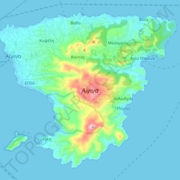
Name: Topografische Karte Aegina, Höhe, Relief.
Durchschnittliche Höhe: 60 m
Minimale Höhe: -2 m
Maximale Höhe: 518 m
Andere topografische Karten
Klicken Sie auf eine Karte, um ihre Topografie, ihre Höhe und ihr Relief anzuzeigen.
Athens
Greece > Attica > Regional Unit of Central Athens
Athens, Municipality of Athens, Regional Unit of Central Athens, Attica, 104 31, Greece
Durchschnittliche Höhe: 178 m
Piraeus
Greece > Attica > Regional Unit of Piraeus > Piraeus
Piraeus, Municipality of Piraeus, Regional Unit of Piraeus, Attica, 18535, Greece
Durchschnittliche Höhe: 96 m
Municipality of Palaio Faliro
Greece > Attica > Municipality of Palaio Faliro
Municipality of Palaio Faliro, Regional Unit of South Athens, Attica, Greece
Durchschnittliche Höhe: 16 m