
Topografische Karte Lago Mascardi
Interaktive Karte
Klicken Sie auf die Karte, um die Höhe anzuzeigen.
Über diese Karte
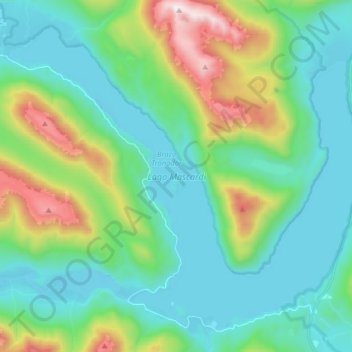
Name: Topografische Karte Lago Mascardi, Höhe, Relief.
Durchschnittliche Höhe: 1.090 m
Minimale Höhe: 796 m
Maximale Höhe: 2.038 m
Andere topografische Karten
Klicken Sie auf eine Karte, um ihre Topografie, ihre Höhe und ihr Relief anzuzeigen.
Playa El Molino
Argentina > Río Negro > San Antonio Oeste > Saco Viejo
Playa El Molino, Saco Viejo, San Antonio Oeste, Departamento San Antonio, Río Negro, Argentina
Durchschnittliche Höhe: 7 m
San Carlos de Bariloche
Argentina > Río Negro > San Carlos de Bariloche
San Carlos de Bariloche, Municipio de San Carlos de Bariloche, Departamento Bariloche, Río Negro, 8400, Argentina
Durchschnittliche Höhe: 1.042 m
Las Grutas
Argentina > Río Negro > Las Grutas
Las Grutas, Departamento San Antonio, Río Negro, Argentina
Durchschnittliche Höhe: 23 m
Lago Gutiérrez
Lago Gutiérrez, Ruta Nacional 40, Villa Lago Gutiérrez, Departamento Bariloche, Río Negro, 8400, Argentina
Durchschnittliche Höhe: 1.175 m