
Topografische Karte Zapopan
Interaktive Karte
Klicken Sie auf die Karte, um die Höhe anzuzeigen.
Über diese Karte
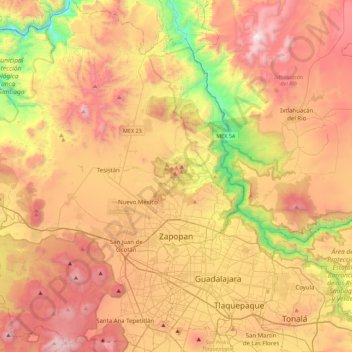
Name: Topografische Karte Zapopan, Höhe, Relief.
Ort: Zapopan, Jalisco, Mexico (20.58479 -103.66503 20.99824 -103.30597)
Durchschnittliche Höhe: 1.586 m
Minimale Höhe: 730 m
Maximale Höhe: 2.377 m
Most of the municipality is flat with another quarter having rolling hills. Altitude varies from 1,500 to 2,000 metres (4,900 to 6,600 ft) above sea level. The main elevations are in the Sierra de la Primavera and include Nejahuete, Tajo and El Chapulin. Superficial water flows mostly in arroyos east to the Grande or Santiago River. In the center of the municipality there are three dams called the Copalita, the Santa Lucia and the San Jose. Winters here are mild and usually are noticeable only in the higher elevations. Average year-round temperature is 22C with highs of 36C and lows of 11C. Rain principally falls from June to October. Vegetation in the municipality varies from pines and holm oaks in the Sierra de la Primavera and species such as jonote (Heliocarpus appendiculatus), strawberry trees and nopals in the lower elevations. While wildlife has nearly disappeared from this area, the Bosque el Nixticuil on the northern edge of the urban sprawl has been designated as a protected natural area and still is home to many mammals, reptiles, amphibians, birds and insects.
Andere topografische Karten
Klicken Sie auf eine Karte, um ihre Topografie, ihre Höhe und ihr Relief anzuzeigen.
Tlajomulco de Zúñiga
Tlajomulco de Zúñiga, Región Centro, Jalisco, Mexico
Durchschnittliche Höhe: 1.670 m
Guadalajara
Mexico > Jalisco > Guadalajara
Guadalajara, Jalisco, 44360, Mexico
Durchschnittliche Höhe: 1.572 m
Río Blanco
Río Blanco, Zapopan, Región Centro, Jalisco, 45158, Mexico
Durchschnittliche Höhe: 1.575 m
Puerto Vallarta
Mexico > Jalisco > Puerto Vallarta
Puerto Vallarta, Región Costa Norte, Jalisco, 48300, Mexico
Durchschnittliche Höhe: 306 m
Tepatitlán
Mexico > Jalisco > Tepatitlán de Morelos
Tepatitlán, Tepatitlán de Morelos, Jalisco, 47690, Mexico
Durchschnittliche Höhe: 1.879 m
San Patricio
San Patricio, Cihuatlán, Jalisco, 48985, Mexico
Durchschnittliche Höhe: 12 m
Lake Chapala
Lake Chapala, Chapala, Jalisco, Mexico
Durchschnittliche Höhe: 1.732 m
Valle de Guadalupe
Valle de Guadalupe, Jalisco, Mexico
Durchschnittliche Höhe: 1.873 m
Lagos de Moreno
Mexico > Jalisco > Lagos de Moreno
Lagos de Moreno, Jalisco, 47400, Mexico
Durchschnittliche Höhe: 1.956 m
San Juan de Ocotán
Mexico > Jalisco > Zapopan > San Juan de Ocotán
San Juan de Ocotán, Zapopan, Jalisco, 45019, Mexico
Durchschnittliche Höhe: 1.666 m
Milpillas
Mexico > Jalisco > Atotonilco el Alto > Milpillas
Milpillas, Atotonilco el Alto, Jalisco, 47775, Mexico
Durchschnittliche Höhe: 1.590 m
Teocaltiche
Mexico > Jalisco > Teocaltiche
Teocaltiche, Jalisco, Mexico
Durchschnittliche Höhe: 1.855 m
Talpa de Allende
Mexico > Jalisco > Talpa de Allende
Talpa de Allende, Jalisco, Mexico
Durchschnittliche Höhe: 1.130 m
Capilla de Guadalupe
Mexico > Jalisco > Tepatitlán de Morelos > Capilla de Guadalupe
Capilla de Guadalupe, Tepatitlán de Morelos, Jalisco, 47601, Mexico
Durchschnittliche Höhe: 2.049 m
Atemajac de Brizuela
Atemajac de Brizuela, Jalisco, Mexico
Durchschnittliche Höhe: 2.014 m
Tlaquepaque
Mexico > Jalisco > Tlaquepaque
Tlaquepaque, San Pedro Tlaquepaque, Jalisco, 45500, Mexico
Durchschnittliche Höhe: 1.562 m
Nevado de Colima
Nevado de Colima, Tuxpan, Jalisco, Mexico
Durchschnittliche Höhe: 3.758 m
Rio Grande de Santiago
Rio Grande de Santiago, Juanacatlán, Jalisco, 45620, Mexico
Durchschnittliche Höhe: 1.481 m
Colima Volcano
Colima Volcano, Tonila, Jalisco, Mexico
Durchschnittliche Höhe: 3.255 m
Playa Camarones
Mexico > Jalisco > Puerto Vallarta
Playa Camarones, Republica de Chile, Gringo Gulch, Pitillal, Puerto Vallarta, Jalisco, 48300, Mexico
Durchschnittliche Höhe: 26 m