Geolokalisieren
👉 Easily get elevation data in JSON, GeoTIFF and KML formats using Elevation API
Vielen Dank für die Unterstützung dieser Website ❤️
Spenden

Topografische Karte Seine-Maritime

Klicken Sie auf die Karte, um die Höhe anzuzeigen.

👉 Easily get elevation data in JSON, GeoTIFF and KML formats using Elevation API
Vielen Dank für die Unterstützung dieser Website ❤️
Spenden

Seine-Maritime

Le climat de la Seine-Maritime est océanique. Il existe des différences de températures entre le littoral et l'intérieur du département. En hiver, les températures enregistrées sur la côte sont plus douces que celles relevées plus à l'est. L'effet inverse est notable en été. Les terres du pays de Bray, situées plus en altitude, connaissent quelques épisodes neigeux en hiver. Les vents dominants viennent du sud-ouest ou de l'ouest. Ils peuvent souffler en tempête en automne et en hiver.

Wikipedia (CC-BY-SA 3.0)

👉 Easily get elevation data in JSON, GeoTIFF and KML formats using Elevation API
Vielen Dank für die Unterstützung dieser Website ❤️
Spenden

Über diese Karte

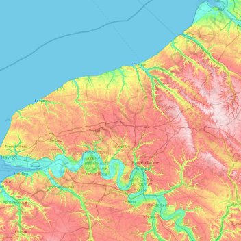
Name: Topografische Karte Seine-Maritime, Höhe, Relief.

Ort: Seine-Maritime, Normandie, France métropolitaine, France (49.25067 0.06577 50.07221 1.79077)

Durchschnittliche Höhe: 85 m

Minimale Höhe: -3 m

Maximale Höhe: 248 m

👉 Easily get elevation data in JSON, GeoTIFF and KML formats using Elevation API
Vielen Dank für die Unterstützung dieser Website ❤️
Spenden

Andere topografische Karten

Klicken Sie auf eine Karte, um ihre Topografie, ihre Höhe und ihr Relief anzuzeigen.

La Forêtrie

France > Normandie > Manche > Montanel

Durchschnittliche Höhe: 95 m

Mont Castre

France > Normandie > Manche > Le Plessis-Lastelle

Le mont Castre, appelé aussi mont Castré, est une montagne du Massif armoricain. Elle est située dans le département de la Manche, sur les communes de Lithaire, du Plessis-Lastelle et de Gerville-la-Forêt. Il culmine à 130 m d'altitude. Chargé d'histoire, on y trouve des vestiges allant de la…

Durchschnittliche Höhe: 69 m

Les Cours

France > Normandie > Orne > Berjou

Durchschnittliche Höhe: 176 m

Entraygues

France > Normandie > Eure > La Trinité-de-Réville

Durchschnittliche Höhe: 189 m

Vielen Dank für die Unterstützung dieser Website ❤️
Spenden

Saint-Germain-sur-Ay-Plage

France > Normandie > Manche

Durchschnittliche Höhe: 3 m

Notre-Dame

France > Normandie > Manche > Lessay

Durchschnittliche Höhe: 18 m

La Bresle

France > Normandie > Eu

Durchschnittliche Höhe: 32 m

Salnel

France > Normandie > Manche > Saint-Germain-sur-Ay

Durchschnittliche Höhe: 10 m

Vielen Dank für die Unterstützung dieser Website ❤️
Spenden

Bellevue

France > Normandie > Manche > Valognes

Durchschnittliche Höhe: 55 m

Coutainville

France > Normandie > Manche

Durchschnittliche Höhe: 11 m

Habloville

France > Normandie > Eure > Saint-Aubin-sur-Gaillon

Durchschnittliche Höhe: 64 m

Mont de Doville

France > Normandie > Manche > Doville

Le mont Doville est une montagne du Massif armoricain. Elle est située dans le département de la Manche, sur la commune de Doville. Il culmine à 129 m d'altitude. Les soldats américains y ont défait des positions allemandes entre le 3 et le 10 juillet 1944 pendant la bataille de La Haye-du-Puits. Il fait…

Durchschnittliche Höhe: 44 m

Vielen Dank für die Unterstützung dieser Website ❤️
Spenden

Le Clos Saint-Jean

France > Normandie > Manche > La Haye-du-Puits

Durchschnittliche Höhe: 54 m

L'Augrumière

France > Normandie > Orne > Carrouges

Durchschnittliche Höhe: 285 m

Moissy

France > Normandie > Orne > Gouffern en Auge > Chambois

Durchschnittliche Höhe: 111 m

Cambercourt

France > Normandie > Orne > Berjou

Durchschnittliche Höhe: 161 m

Vielen Dank für die Unterstützung dieser Website ❤️
Spenden

Villa Sayer

France > Normandie > Calvados > Glanville > Lieu Émisse

Durchschnittliche Höhe: 96 m

Les Hazes

France > Normandie > Orne > Écouché-les-Vallées

Durchschnittliche Höhe: 162 m

La Cauvinière

France > Normandie > Manche > Hébécrevon

Durchschnittliche Höhe: 59 m

Hameau Clapet

France > Normandie > Manche > Pierreville

Durchschnittliche Höhe: 75 m

Vielen Dank für die Unterstützung dieser Website ❤️
Spenden

Le Haut Candol

France > Normandie > Manche > Saint-Lô

Durchschnittliche Höhe: 48 m

Le Haut des Cours

France > Normandie > Seine-Maritime > Norville

Durchschnittliche Höhe: 42 m

Le Hameau Sauvage

France > Normandie > Manche > La Hague > Beaumont-Hague

Durchschnittliche Höhe: 131 m

La Fosserie

France > Normandie > Manche > Coutances

Durchschnittliche Höhe: 95 m

Vielen Dank für die Unterstützung dieser Website ❤️
Spenden

Joyeux

France > Normandie > Seine-Maritime > Ypreville-Biville

Durchschnittliche Höhe: 124 m

La Vallée

France > Normandie > Calvados > Mutrécy

Durchschnittliche Höhe: 72 m

Hameau Gilles

France > Normandie > Manche > Anneville-en-Saire

Durchschnittliche Höhe: 9 m

Vielen Dank für die Unterstützung dieser Website ❤️
Spenden

Château de Saint-Germain

France > Normandie > Calvados > Marolles

Durchschnittliche Höhe: 150 m

Les Basses Planches

France > Normandie > Calvados > Saint-Omer

Durchschnittliche Höhe: 185 m

Le Pont de la Mousse

France > Normandie > Calvados > Saint-Rémy

Durchschnittliche Höhe: 100 m

Vielen Dank für die Unterstützung dieser Website ❤️
Spenden

Le Melleret

France > Normandie > Manche > Bricquebec-en-Cotentin > Bricquebec

Durchschnittliche Höhe: 57 m

Domfront

France > Normandie > Orne > Domfront en Poiraie

Durchschnittliche Höhe: 166 m

Les Loges

France > Normandie > Eure > Écaquelon

Durchschnittliche Höhe: 118 m

Le Moulin à Vent

France > Normandie > Orne > Les Menus

Durchschnittliche Höhe: 220 m

Vielen Dank für die Unterstützung dieser Website ❤️
Spenden

Le Val de May

France > Normandie > Calvados > Saint-Martin-de-May > May-sur-Orne

Durchschnittliche Höhe: 49 m

Hameau du Cap Lévi

France > Normandie > Manche > Fermanville

Durchschnittliche Höhe: 15 m

La Mignarderie

France > Normandie > Manche > Cambernon

Durchschnittliche Höhe: 127 m

La Petite Mortrée

France > Normandie > Orne > Mortrée

Durchschnittliche Höhe: 186 m

Vielen Dank für die Unterstützung dieser Website ❤️
Spenden

Crèvecœur

France > Normandie > Eure > Clef-Vallée-d'Eure

Durchschnittliche Höhe: 77 m

Pressagny-le-Val

France > Normandie > Eure > Notre-Dame-de-l'Isle

Durchschnittliche Höhe: 85 m

Boisgeloup

France > Normandie > Eure > Gisors

Durchschnittliche Höhe: 88 m

La Houleterie

France > Normandie > Eure > Caumont

Durchschnittliche Höhe: 93 m

Vielen Dank für die Unterstützung dieser Website ❤️
Spenden

La Palaserie

France > Normandie > Orne > Pouvrai

Durchschnittliche Höhe: 131 m

Les Hauts Vents

France > Normandie > Manche > Tessy-Bocage

Durchschnittliche Höhe: 104 m

La Brique

France > Normandie > Manche > Saint-Joseph

Durchschnittliche Höhe: 51 m

Fumichon

France > Normandie > Calvados > Neuilly-la-Forêt

Durchschnittliche Höhe: 17 m

Vielen Dank für die Unterstützung dieser Website ❤️
Spenden

Le Souci

France > Normandie > Orne > Charencey

Durchschnittliche Höhe: 224 m

Les Moulins

France > Normandie > Manche > Barneville-Carteret

Durchschnittliche Höhe: 32 m

Les Mariaux

France > Normandie > Eure > Bois-Arnault

Durchschnittliche Höhe: 204 m

Saint-Georges

France > Normandie > Orne > Pontchardon

Durchschnittliche Höhe: 183 m

Vielen Dank für die Unterstützung dieser Website ❤️
Spenden

Sérigny

France > Normandie > Orne

Durchschnittliche Höhe: 196 m

Le Hamel

France > Normandie > Manche > Condé-sur-Vire > Les Carrières

Durchschnittliche Höhe: 51 m

Secqueville

France > Normandie > Calvados > Le Castelet > Garcelles-Secqueville

Durchschnittliche Höhe: 65 m

Autrebosc

France > Normandie > Eure > Tourneville

Durchschnittliche Höhe: 117 m

Vielen Dank für die Unterstützung dieser Website ❤️
Spenden

Les Grandies

France > Normandie > Manche > Sainte-Marie-du-Mont

Durchschnittliche Höhe: 7 m

La Jeannerie

France > Normandie > Manche > Blainville-sur-Mer

Durchschnittliche Höhe: 29 m

Le Haras

France > Normandie > Manche > Picauville

Durchschnittliche Höhe: 17 m

Hameau de Haut

France > Normandie > Manche > Les Moitiers-en-Bauptois

Durchschnittliche Höhe: 15 m

Vielen Dank für die Unterstützung dieser Website ❤️
Spenden

Fée

France > Normandie > Orne > Ceton

Durchschnittliche Höhe: 144 m

La Moisière

France > Normandie > Orne > Bonsmoulins

Durchschnittliche Höhe: 250 m

Saint Germain-De-Loisé

France > Normandie > Orne > Mortagne-au-Perche

Durchschnittliche Höhe: 210 m

Le Hardelle

France > Normandie > Manche > Bretteville

Durchschnittliche Höhe: 50 m

Vielen Dank für die Unterstützung dieser Website ❤️
Spenden

Le Launay

France > Normandie > Calvados > Aurseulles

Durchschnittliche Höhe: 126 m

Mont Canisy

France > Normandie > Calvados > Benerville-sur-Mer

Durchschnittliche Höhe: 41 m

La Sentelle

France > Normandie > Eure > Mesnil-en-Ouche > La Roussière

Durchschnittliche Höhe: 192 m

Gouville

France > Normandie > Eure > Mesnils-sur-Iton

Durchschnittliche Höhe: 164 m

Vielen Dank für die Unterstützung dieser Website ❤️
Spenden

La Ferme des Sapins

France > Normandie > Seine-Maritime > Yport

Durchschnittliche Höhe: 65 m

Le Grand Samoi

France > Normandie > Orne > Saint-Pierre-du-Regard

Durchschnittliche Höhe: 139 m

Le Frechot

France > Normandie > Manche > Le Grand-Celland

Durchschnittliche Höhe: 177 m

Écambosc

France > Normandie > Eure > Quittebeuf

Durchschnittliche Höhe: 142 m

Vielen Dank für die Unterstützung dieser Website ❤️
Spenden

La Maillardière

France > Normandie > Orne > Montilly-sur-Noireau

Durchschnittliche Höhe: 128 m

Bellevue

France > Normandie > Seine-Maritime > Saint-Jacques-sur-Darnétal

Durchschnittliche Höhe: 148 m

Le Mesnil

France > Normandie > Eure > Acon

Durchschnittliche Höhe: 160 m

Les Ervolus

France > Normandie > Eure > Le Plessis-Grohan

Durchschnittliche Höhe: 145 m

Vielen Dank für die Unterstützung dieser Website ❤️
Spenden

La Saussaie

France > Normandie > Orne > Bretoncelles

Durchschnittliche Höhe: 161 m

La Cinquantaine

France > Normandie > Calvados > Blonville-sur-Mer

Durchschnittliche Höhe: 29 m

Le Bout du Bas

France > Normandie > Seine-Maritime > Offranville

Durchschnittliche Höhe: 74 m

Fort Fresnay

France > Normandie > Orne > Fresnay-le-Samson

Durchschnittliche Höhe: 175 m

Vielen Dank für die Unterstützung dieser Website ❤️
Spenden

La Dandière

France > Normandie > Orne > Sainte-Honorine-la-Guillaume

Durchschnittliche Höhe: 216 m

La Bunodière

France > Normandie > Orne > Athis-Val-de-Rouvre > Athis-de-l'Orne

Durchschnittliche Höhe: 218 m

Le Mont Martin

France > Normandie > Eure > Gaillon

Durchschnittliche Höhe: 85 m

Plage de St Adresse

France > Normandie > Seine-Maritime > Le Havre

Durchschnittliche Höhe: 40 m

Vielen Dank für die Unterstützung dieser Website ❤️
Spenden

Longueville

France > Normandie > Calvados > Ranville

Durchschnittliche Höhe: 18 m

Huanville

France > Normandie > Manche > Port-Bail-sur-Mer > Saint-Lô-d'Ourville

Durchschnittliche Höhe: 30 m

Manoir de Méterville

France > Normandie > Manche > Gorges > La Scellerie

Durchschnittliche Höhe: 13 m

Le Pont de Vie

France > Normandie > Orne > Vimoutiers

Durchschnittliche Höhe: 165 m

Vielen Dank für die Unterstützung dieser Website ❤️
Spenden

Groussey

France > Normandie > Manche > Jullouville

Durchschnittliche Höhe: 45 m

La Bretonne

France > Normandie > Manche > Barfleur

Durchschnittliche Höhe: 6 m

Étang de la Visance

France > Normandie > Orne > Chanu

Durchschnittliche Höhe: 254 m

La Millerette

France > Normandie > Eure > Sylvains-lès-Moulins

Durchschnittliche Höhe: 150 m

Vielen Dank für die Unterstützung dieser Website ❤️
Spenden

Le Poiré

France > Normandie > Manche > Morville

Durchschnittliche Höhe: 30 m

La Garenne

France > Normandie > Calvados > Benerville-sur-Mer

Durchschnittliche Höhe: 21 m

Les Hauts Vents

France > Normandie > Manche > Bricqueville-sur-Mer

Durchschnittliche Höhe: 44 m

Le Hameau du Broquet

France > Normandie > Manche > Teurthéville-Bocage

Durchschnittliche Höhe: 69 m

Vielen Dank für die Unterstützung dieser Website ❤️
Spenden

Saint-Siméon

France > Normandie > Manche > Port-Bail-sur-Mer > Portbail

Durchschnittliche Höhe: 20 m

La Poterie

France > Normandie > Manche > Lengronne

Durchschnittliche Höhe: 97 m

Le Pont Gaché

France > Normandie > Manche > Gavray-sur-Sienne > Gavray

Durchschnittliche Höhe: 77 m

Vielen Dank für die Unterstützung dieser Website ❤️
Spenden