
Topografische Karte Picton
Interaktive Karte
Klicken Sie auf die Karte, um die Höhe anzuzeigen.
Über diese Karte
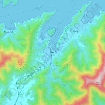
Name: Topografische Karte Picton, Höhe, Relief.
Ort: Picton, Marlborough, 7220, New Zealand (-41.33092 173.96691 -41.25092 174.04691)
Durchschnittliche Höhe: 193 m
Minimale Höhe: -1 m
Maximale Höhe: 951 m
On the land side, Picton is surrounded by hills and mountains, including Te Tara-o-Te-Marama/Mount Freeth to the west, the Robertson Range to the south and Mount McCormick to the east. The Elevation Saddle connects southwest of the town with the Tuamarina River valley and contains the main land transport routes between Picton and the rest of the South Island.
Andere topografische Karten
Klicken Sie auf eine Karte, um ihre Topografie, ihre Höhe und ihr Relief anzuzeigen.
Blumine Island / Ōruawairua
Blumine Island / Ōruawairua, Marlborough, New Zealand
Durchschnittliche Höhe: 37 m
Mount Blanc
Mount Blanc, Marlborough, New Zealand
Durchschnittliche Höhe: 823 m
Robin Hood Bay
Robin Hood Bay, Marlborough, New Zealand
Durchschnittliche Höhe: 78 m
Barometer
Barometer, Marlborough, 7240, New Zealand
Durchschnittliche Höhe: 1.397 m
Rarangi
New Zealand > Marlborough > Rarangi
Rarangi, Marlborough, New Zealand
Durchschnittliche Höhe: 83 m
Devils Staircase
Devils Staircase, Marlborough, New Zealand
Durchschnittliche Höhe: 372 m
Yarra River
Yarra River, Marlborough, New Zealand
Durchschnittliche Höhe: 1.233 m
Tapuae-o-Uenuku
Tapuae-o-Uenuku, Marlborough, New Zealand
Durchschnittliche Höhe: 2.302 m
Blenheim
Blenheim, Marlborough, 7301, New Zealand
Durchschnittliche Höhe: 20 m
Mitre Peak
Mitre Peak, Marlborough, New Zealand
Durchschnittliche Höhe: 1.223 m
Wairau Valley
New Zealand > Marlborough > Wairau Valley
Wairau Valley, Marlborough, New Zealand
Durchschnittliche Höhe: 185 m