Geolokalisieren

Topografische Karte Font-Romeu

Interaktive Karte

Klicken Sie auf die Karte, um die Höhe anzuzeigen.

Über diese Karte

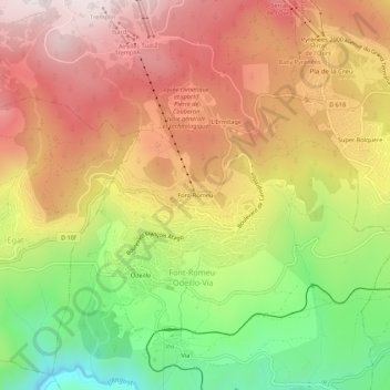
Name: Topografische Karte Font-Romeu, Höhe, Relief.

Ort: Font-Romeu, Font-Romeu-Odeillo-Via, Prades, Pyrénées-Orientales, Occitanie, France métropolitaine, 66120, France (42.48503 2.02198 42.52503 2.06198)

Durchschnittliche Höhe: 1.710 m

Minimale Höhe: 1.311 m

Maximale Höhe: 2.044 m

Andere topografische Karten

Klicken Sie auf eine Karte, um ihre Topografie, ihre Höhe und ihr Relief anzuzeigen.

Via

France > Occitanie > Pyrénées-Orientales > Font-Romeu-Odeillo-Via

Via, Font-Romeu-Odeillo-Via, Prades, Pyrénées-Orientales, Occitanie, France métropolitaine, 66120, France

Durchschnittliche Höhe: 1.551 m

Odeillo

France > Occitanie > Pyrénées-Orientales > Font-Romeu-Odeillo-Via

Odeillo, Font-Romeu-Odeillo-Via, Prades, Pyrénées-Orientales, Occitanie, France métropolitaine, 66120, France

Durchschnittliche Höhe: 1.631 m

L'Ermitage

France > Occitanie > Pyrénées-Orientales > Font-Romeu-Odeillo-Via

L'Ermitage, Font-Romeu-Odeillo-Via, Prades, Pyrénées-Orientales, Occitanie, France métropolitaine, 66120, France

Durchschnittliche Höhe: 1.785 m