
Spenden
Topografische Karte Lorgues
Klicken Sie auf die Karte, um die Höhe anzuzeigen.
Spenden
Lorgues
In terms of geology Lorgues is, for the most part, underlain by Triassic and Jurassic limestones which give rise to gentle hills and narrow flat-bottomed valleys, the most important of which are the valleys of the rivers Argens and Florièye which border the commune on the south and east. The town centre stands at an elevation of 210m, with the hill of Saint Ferréol to the east rising to 320m.
Spenden
Über diese Karte
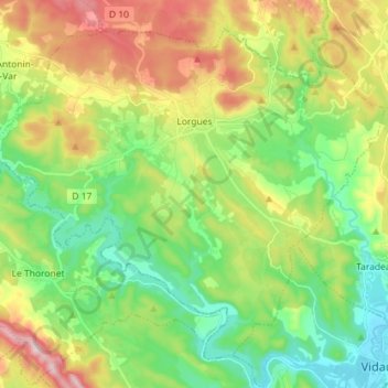
Name: Topografische Karte Lorgues, Höhe, Relief.
Durchschnittliche Höhe: 189 m
Minimale Höhe: 50 m
Maximale Höhe: 428 m
Spenden
Andere topografische Karten
Klicken Sie auf eine Karte, um ihre Topografie, ihre Höhe und ihr Relief anzuzeigen.
Le Canadel
France > Provence-Alpes-Côte d'Azur > Var > Rayol-Canadel-sur-Mer
Durchschnittliche Höhe: 135 m
Spenden
Le Camp du Castellet
France > Provence-Alpes-Côte d'Azur > Var > Le Castellet
Durchschnittliche Höhe: 371 m
forêt de Sainte barbe
France > Provence-Alpes-Côte d'Azur > Var > Draguignan
Durchschnittliche Höhe: 235 m
Le Brusc
France > Provence-Alpes-Côte d'Azur > Var > Six-Fours-les-Plages
Durchschnittliche Höhe: 20 m
Spenden
Ruines du Barrage de Malpasset
France > Provence-Alpes-Côte d'Azur > Var > Fréjus
Durchschnittliche Höhe: 118 m
Val d'Esquieres
France > Provence-Alpes-Côte d'Azur > Var > Roquebrune-sur-Argens
Durchschnittliche Höhe: 82 m
Plage de Bonporteau
France > Provence-Alpes-Côte d'Azur > Var > Cavalaire-sur-Mer
Durchschnittliche Höhe: 41 m
Spenden
Les Vernades
France > Provence-Alpes-Côte d'Azur > Var > La Garde-Freinet
Durchschnittliche Höhe: 214 m
Spenden
Le Brusc
France > Provence-Alpes-Côte d'Azur > Var > Six-Fours-les-Plages
Durchschnittliche Höhe: 20 m
Le Plan
France > Provence-Alpes-Côte d'Azur > Var > Plan-d'Aups-Sainte-Baume
Durchschnittliche Höhe: 720 m
Spenden
Margin
France > Provence-Alpes-Côte d'Azur > Var > Vinon-sur-Verdon > Margin
Durchschnittliche Höhe: 329 m
Les Aires Longues
France > Provence-Alpes-Côte d'Azur > Var > Ginasservis > Les Aires Longues
Durchschnittliche Höhe: 411 m
Draguignan
France > Provence-Alpes-Côte d'Azur > Var > Draguignan > Draguignan
The elevation is 200 m. The highest hill near Draguignan is Malmont (551 m). The main river near Draguignan is the Nartuby.
Durchschnittliche Höhe: 288 m
Spenden
Île des Embiez
France > Provence-Alpes-Côte d'Azur > Var > Six-Fours-les-Plages > Le Brusc
Durchschnittliche Höhe: 2 m
Fort de Brégançon
France > Provence-Alpes-Côte d'Azur > Var > Bormes-les-Mimosas
Durchschnittliche Höhe: 9 m
Jospeh Allet
France > Provence-Alpes-Côte d'Azur > Var > Draguignan > Draguignan > Saint François
Durchschnittliche Höhe: 207 m
Spenden
Château de La Verdière
France > Provence-Alpes-Côte d'Azur > Var > La Verdière
Durchschnittliche Höhe: 440 m