
Topografische Karte Ninety Six
Interaktive Karte
Klicken Sie auf die Karte, um die Höhe anzuzeigen.
Über diese Karte
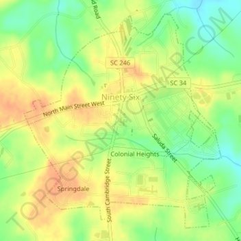
Name: Topografische Karte Ninety Six, Höhe, Relief.
Ort: Ninety Six, Greenwood County, South Carolina, United States (34.16043 -82.03706 34.18443 -82.01036)
Durchschnittliche Höhe: 162 m
Minimale Höhe: 139 m
Maximale Höhe: 179 m
Andere topografische Karten
Klicken Sie auf eine Karte, um ihre Topografie, ihre Höhe und ihr Relief anzuzeigen.
Canterbury
United States > South Carolina > Greenwood County
Canterbury, Greenwood County, South Carolina, 29649, United States
Durchschnittliche Höhe: 187 m
Lake Greenwood
United States > South Carolina > Greenwood County > Dyson
Lake Greenwood, Dyson, Greenwood County, South Carolina, United States
Durchschnittliche Höhe: 160 m
Hodges
United States > South Carolina > Greenwood County
Hodges, Greenwood County, South Carolina, United States
Durchschnittliche Höhe: 200 m
Ninety Six National Historic Site
United States > South Carolina > Greenwood County
Ninety Six National Historic Site, Greenwood County, South Carolina, United States
Durchschnittliche Höhe: 144 m
Promised Land
United States > South Carolina > Greenwood County > Promised Land
Promised Land, Greenwood County, South Carolina, United States
Durchschnittliche Höhe: 177 m
Friendship
United States > South Carolina > Greenwood County
Friendship, Greenwood County, South Carolina, United States
Durchschnittliche Höhe: 167 m