
Topografische Karte Little Missouri River
Interaktive Karte
Klicken Sie auf die Karte, um die Höhe anzuzeigen.
Über diese Karte
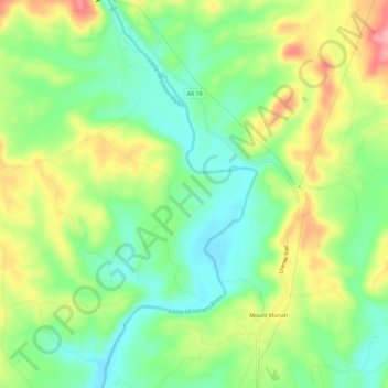
Name: Topografische Karte Little Missouri River, Höhe, Relief.
Durchschnittliche Höhe: 159 m
Minimale Höhe: 112 m
Maximale Höhe: 227 m
Andere topografische Karten
Klicken Sie auf eine Karte, um ihre Topografie, ihre Höhe und ihr Relief anzuzeigen.
Crater of Diamonds State Park
United States > Arkansas > Pike County > Murfreesboro > Kimberley
Crater of Diamonds State Park, Kimberley, Murfreesboro, Pike County, Arkansas, 71958, United States
Durchschnittliche Höhe: 106 m
Antoine
United States > Arkansas > Pike County
Antoine, Pike County, Arkansas, United States
Durchschnittliche Höhe: 90 m
Glenwood
United States > Arkansas > Pike County > Glenwood
Glenwood, Pike County, Arkansas, United States
Durchschnittliche Höhe: 193 m
Delight
United States > Arkansas > Pike County > Delight
Delight, Pike County, Arkansas, 71940, United States
Durchschnittliche Höhe: 119 m
Lake Greeson
United States > Arkansas > Pike County
Lake Greeson, Pike County, Arkansas, 71950, United States
Durchschnittliche Höhe: 195 m
Murfreesboro
United States > Arkansas > Pike County
Murfreesboro, Pike County, Arkansas, 71958, United States
Durchschnittliche Höhe: 114 m