
Spenden
Topografische Karte Williams City Limits
Klicken Sie auf die Karte, um die Höhe anzuzeigen.
Spenden
Über diese Karte
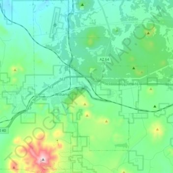
Name: Topografische Karte Williams City Limits, Höhe, Relief.
Durchschnittliche Höhe: 2.140 m
Minimale Höhe: 1.962 m
Maximale Höhe: 2.811 m
Spenden
Andere topografische Karten
Klicken Sie auf eine Karte, um ihre Topografie, ihre Höhe und ihr Relief anzuzeigen.
Spenden
Flagstaff
United States > Arizona > Coconino County
Flagstaff is the county seat of Coconino County. According to the United States Census Bureau, the city has a total area of 63.9 square miles (165.5 km2), of which only 0.03 square miles (0.08 km2) (0.08%) is water. Flagstaff lies at approximately 7,000 feet (2,130 m) elevation, and is surrounded by the…
Durchschnittliche Höhe: 2.230 m
Spenden
Valle
United States > Arizona > Coconino County
Valle (Grand Canyon Junction) is a census-designated place in Coconino County, Arizona, United States. As of the 2010 US Census the population of Valle was 832. It lies at an altitude of 5,994 feet (1,827 m), at the junction of U.S. Route 180 and State Route 64. Its attractions include the Valle Airport (40G),…
Durchschnittliche Höhe: 1.860 m
Spenden
Spenden
Spenden
Cameron
United States > Arizona > Coconino County
Cameron is located on the Navajo Nation. Elevation is 4,216 feet (1,285 m) above sea level. It is immediately south of the Little Colorado River, just above the beginning of the Little Colorado River Gorge and the stream's descent into the Grand Canyon. Cameron lies at the intersection of US 89 and State Route…
Durchschnittliche Höhe: 1.331 m
Spenden
Spenden
Grand Canyon Navajo Tribal Park
United States > Arizona > Coconino County
Durchschnittliche Höhe: 1.824 m
Spenden
Spenden
Gray Mountain
United States > Arizona > Coconino County > Gray Mountain
Durchschnittliche Höhe: 1.520 m
Spenden
Page
United States > Arizona > Coconino County > Page
Unlike other cities in the area, Page was founded in 1957 as a housing community for workers and their families during the construction of nearby Glen Canyon Dam on the Colorado River. Its 17-square-mile (44 km2) site was obtained in a land exchange with the Navajo Nation. The city is perched atop Manson Mesa…
Durchschnittliche Höhe: 1.242 m
Spenden
Spenden
South Rim
United States > Arizona > Coconino County > Grand Canyon Village
Durchschnittliche Höhe: 1.858 m
Spenden