Topografische Karte Historic Southfields Pond
Klicken Sie auf die Karte, um die Höhe anzuzeigen.
Über diese Karte
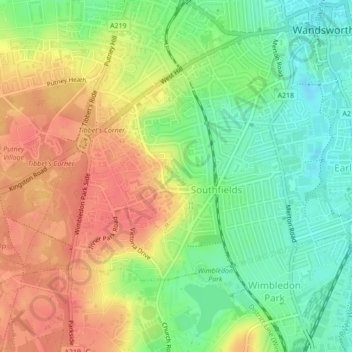
Name: Topografische Karte Historic Southfields Pond, Höhe, Relief.
Durchschnittliche Höhe: 31 m
Minimale Höhe: 2 m
Maximale Höhe: 58 m

Klicken Sie auf die Karte, um die Höhe anzuzeigen.
Name: Topografische Karte Historic Southfields Pond, Höhe, Relief.
Durchschnittliche Höhe: 31 m
Minimale Höhe: 2 m
Maximale Höhe: 58 m