Geolokalisieren
👉 Easily get elevation data in JSON, GeoTIFF and KML formats using Elevation API
Vielen Dank für die Unterstützung dieser Website ❤️
Spenden

Topografische Karte Bahour Taluk

Klicken Sie auf die Karte, um die Höhe anzuzeigen.

👉 Easily get elevation data in JSON, GeoTIFF and KML formats using Elevation API
Vielen Dank für die Unterstützung dieser Website ❤️
Spenden

Über diese Karte

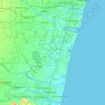
Name: Topografische Karte Bahour Taluk, Höhe, Relief.

Ort: Bahour Taluk, Puducherry District, Puducherry, India (11.77523 79.59942 11.89131 79.80680)

Durchschnittliche Höhe: 7 m

Minimale Höhe: -5 m

Maximale Höhe: 44 m

👉 Easily get elevation data in JSON, GeoTIFF and KML formats using Elevation API
Vielen Dank für die Unterstützung dieser Website ❤️
Spenden

Andere topografische Karten

Klicken Sie auf eine Karte, um ihre Topografie, ihre Höhe und ihr Relief anzuzeigen.

Puducherry

India > Puducherry > Puducherry Taluk

The topography of Pondicherry is the same as that of coastal Tamil Nadu. Pondicherry's average elevation is at sea level and includes a number of sea inlets, referred to locally as "backwaters". Pondicherry experiences extreme coastal erosion as a result of a breakwater constructed in 1989, just to the south…

Durchschnittliche Höhe: 10 m

Veerampattinam

India > Puducherry > Puducherry Taluk

Durchschnittliche Höhe: 3 m

Karaikal

India > Puducherry > Karaikal Taluk

Durchschnittliche Höhe: 3 m

Ariyur

India > Puducherry > Villianur Taluk

Durchschnittliche Höhe: 16 m

Vielen Dank für die Unterstützung dieser Website ❤️
Spenden

Oussudu WLS

India > Puducherry > Villianur Taluk > Koodapakkam

Durchschnittliche Höhe: 13 m

Oulgaret

India > Puducherry > Ozhukarai Taluk

Durchschnittliche Höhe: 18 m

Mahe

India > Puducherry > Mahe Taluk

Durchschnittliche Höhe: 10 m

moolakulam

India > Puducherry > Ozhukarai Taluk > Oulgaret

Durchschnittliche Höhe: 12 m

Vielen Dank für die Unterstützung dieser Website ❤️
Spenden

Mahe

India > Puducherry > Mahe Taluk

Durchschnittliche Höhe: 10 m

Puducherry

India > Puducherry > Puducherry Taluk

The topography of Pondicherry is the same as that of coastal Tamil Nadu. Pondicherry's average elevation is at sea level and includes a number of sea inlets, referred to locally as "backwaters". Pondicherry experiences extreme coastal erosion as a result of a breakwater constructed in 1989, just to the south…

Durchschnittliche Höhe: 10 m

Karaikal

India > Puducherry > Karaikal Taluk

Durchschnittliche Höhe: 3 m