
Topografische Karte Barnwell State Park
Interaktive Karte
Klicken Sie auf die Karte, um die Höhe anzuzeigen.
Über diese Karte
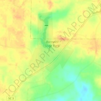
Name: Topografische Karte Barnwell State Park, Höhe, Relief.
Durchschnittliche Höhe: 83 m
Minimale Höhe: 61 m
Maximale Höhe: 95 m
Andere topografische Karten
Klicken Sie auf eine Karte, um ihre Topografie, ihre Höhe und ihr Relief anzuzeigen.
Barnwell
United States > South Carolina > Barnwell County
Barnwell, Barnwell County, South Carolina, 29812, United States
Durchschnittliche Höhe: 64 m
Elko
United States > South Carolina > Barnwell County
Elko, Barnwell County, South Carolina, United States
Durchschnittliche Höhe: 99 m
Barnwell State Park
United States > South Carolina > Barnwell County > Blackville
Barnwell State Park, Blackville, Barnwell County, South Carolina, United States
Durchschnittliche Höhe: 84 m
Williston
United States > South Carolina > Barnwell County
Williston, Barnwell County, South Carolina, 29853, United States
Durchschnittliche Höhe: 102 m
Hilda
United States > South Carolina > Barnwell County
Hilda, Barnwell County, South Carolina, 29813, United States
Durchschnittliche Höhe: 78 m
Blackville
United States > South Carolina > Barnwell County
Blackville, Barnwell County, South Carolina, 29817, United States
Durchschnittliche Höhe: 85 m
Barnwell
United States > South Carolina > Barnwell County > Barnwell
Barnwell, Barnwell County, South Carolina, 29812, United States
Durchschnittliche Höhe: 65 m
Snelling
United States > South Carolina > Barnwell County
Snelling, Barnwell County, South Carolina, United States
Durchschnittliche Höhe: 73 m