
Topografische Karte Reitz
Interaktive Karte
Klicken Sie auf die Karte, um die Höhe anzuzeigen.
Über diese Karte
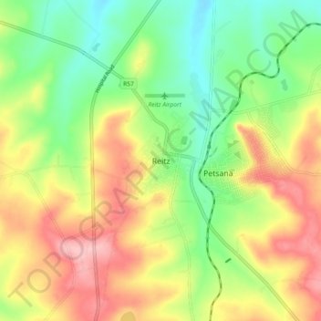
Name: Topografische Karte Reitz, Höhe, Relief.
Durchschnittliche Höhe: 1.648 m
Minimale Höhe: 1.585 m
Maximale Höhe: 1.724 m
Reitz is located in the north-eastern part of the Free State province, 300 kilometres (190 mi) north-east of Bloemfontein and 180 kilometres (110 mi) south of Johannesburg. It lies roughly halfway between the towns of Bethlehem and Frankfort, at an elevation of 1,630 metres (5,350 ft).
Andere topografische Karten
Klicken Sie auf eine Karte, um ihre Topografie, ihre Höhe und ihr Relief anzuzeigen.
Arlington
South Africa > Free State > Thabo Mofutsanyana District Municipality > Nketoana Local Municipality > Arlington
Arlington, Nketoana Local Municipality, Thabo Mofutsanyana District Municipality, Free State, South Africa
Durchschnittliche Höhe: 1.569 m
Lindley
South Africa > Free State > Thabo Mofutsanyana District Municipality > Nketoana Local Municipality > Lindley
Lindley, Nketoana Local Municipality, Thabo Mofutsanyana District Municipality, Free State, South Africa
Durchschnittliche Höhe: 1.540 m
Nketoana Ward 6
South Africa > Free State > Thabo Mofutsanyana District Municipality > Nketoana Local Municipality
Nketoana Ward 6, Nketoana Local Municipality, Thabo Mofutsanyana District Municipality, Free State, South Africa, Pietersfontein Dam
Durchschnittliche Höhe: 1.689 m
Petrus Steyn
South Africa > Free State > Thabo Mofutsanyana District Municipality > Nketoana Local Municipality
Petrus Steyn, Nketoana Local Municipality, Thabo Mofutsanyana District Municipality, Free State, South Africa
Durchschnittliche Höhe: 1.688 m