
Topografische Karte Mount Colah
Klicken Sie auf die Karte, um die Höhe anzuzeigen.
Mount Colah
Mount Colah is 5 km north of Hornsby, the nearest major town centre. It is one of the most northerly suburbs of Sydney and is where the "Welcome to Sydney" sign is located. Mount Colah is the second highest suburb in Sydney by elevation. Considered one of Sydney's leafier suburbs, streets are clustered around the Pacific Highway. Mount Colah is bordered to the east by the Ku-ring-gai Chase National Park.
Über diese Karte
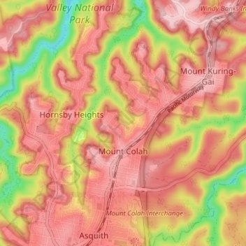
Name: Topografische Karte Mount Colah, Höhe, Relief.
Durchschnittliche Höhe: 152 m
Minimale Höhe: 13 m
Maximale Höhe: 224 m
Andere topografische Karten
Klicken Sie auf eine Karte, um ihre Topografie, ihre Höhe und ihr Relief anzuzeigen.