
Topografische Karte San Carlos de Bariloche
Interaktive Karte
Klicken Sie auf die Karte, um die Höhe anzuzeigen.
Über diese Karte
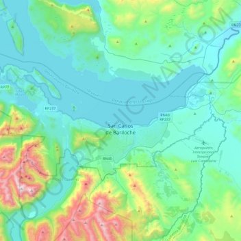
Name: Topografische Karte San Carlos de Bariloche, Höhe, Relief.
Durchschnittliche Höhe: 1.042 m
Minimale Höhe: 756 m
Maximale Höhe: 2.348 m
Andere topografische Karten
Klicken Sie auf eine Karte, um ihre Topografie, ihre Höhe und ihr Relief anzuzeigen.
Los Tilos
Argentina > Río Negro > Cipolletti
Los Tilos, Cipolletti, Municipio de Cipolletti, Departamento General Roca, Río Negro, R8324, Argentina
Durchschnittliche Höhe: 264 m
Casa de Piedra
Argentina > Río Negro > San Carlos de Bariloche
Casa de Piedra, San Carlos de Bariloche, Municipio de San Carlos de Bariloche, Departamento Bariloche, Río Negro, 8400, Argentina
Durchschnittliche Höhe: 804 m
Lago Gutiérrez
Lago Gutiérrez, Ruta Nacional 40, Villa Lago Gutiérrez, Departamento Bariloche, Río Negro, 8400, Argentina
Durchschnittliche Höhe: 1.175 m